Asprokklisiá geodata
Asprokklisiá (Thessaly) is a populated place; located in Greece in Europe/Athens (GMT+3) time zone. With population of 628 people, there are 1530 cities with bigger population in this country. Compared to other cities in Greece, 65% of cities are located further ↓South; 79.4% of cities are located further →East and 92.2% of cities have lower elevation than Asprokklisiá. Note1


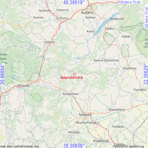
Asprokklisiá GPS coordinates[2]
39° 51' 1.8" North, 21° 39' 47.376" East
| Map corner | latitude | longitude |
|---|---|---|
| Upper-left | 40.38818°, | 20.96004° |
| Center: | 39.8505°, | 21.66316° |
| Lower-right: | 39.30858°, | 22.36629° |
| Map W x H: | 120×120 km | = 74.6×74.6mi |
| max Lat: | 41.72048° ⇑35% North |
| Asprokklisiá: | 39.8505° |
| min Lat: | ⇓65% South 34.8346° |
| min Long | Asprokklisiá | max Long |
| 19.40494° | 21.66316° | 29.59361° |
| W 20.6%⇐ | ⇒79.4% E |
Elevation
Elevation of Asprokklisiá is 580 m = 1903 ft, and this is 411.1 m = 1349 ft above average elevation for this country.
| Max E: |
1439 m = 4721 ft | 7.8% |
| Asprokklisiá | 580 m 1903 ft | |
| Avg. | 168.9 m = 554 ft | |
Min E: |
0 m = 0 ft | 92.2% |
See also: Greece elevation on elevation.city.
Geographical zone
Asprokklisiá is located in North temperate zone (between Tropic of Cancer and the Arctic Circle). Distance of this Northern Tropic circle is 1825 km =1134 mi to South.| Distance of | km | miles | from Asprokklisiá |
|---|---|---|---|
| North Pole | 5576.1 | 3464.8 | to North |
| Arctic Circle | 2970.2 | 1845.6 | to North |
| Tropic Cancer | 1825 | 1134 | to South |
| Equator | 4431 | 2753.3 | to South |


Nearby cities:
15 places around Asprokklisiá: (largest is in red/bold)
• Agiófyllo
8.8 km =5.5 mi,  279°
279°
• Agnantiá
17 km =10.6 mi, 276°
• Deskáti
15 km =9.3 mi,  56°
56°
• Diáva
18.9 km =11.7 mi,  201°
201°
• Dímitra
10.7 km =6.6 mi,  359°
359°
• Eláti
19.8 km =12.3 mi,  43°
43°
• Kalampáka
16.5 km =10.3 mi,  190°
190°
• Karperó
11.4 km =7.1 mi,  340°
340°
• Kastráki
15.3 km =9.5 mi, 194°
• Oxýneia
15 km =9.3 mi,  259°
259°
• Plátanos
23 km =14.3 mi,  156°
156°
• Rízoma
21.6 km =13.4 mi, 163°
• Theópetra
19.7 km =12.2 mi,  174°
174°
• Vasilikí
23.7 km =14.7 mi, 171°
• Ávra
15.7 km =9.8 mi, 171°
Sources, notices
• [Note1] Compared only with cities in Greece existing in our database
• [Src1] Map data: © OpenStreetMap contributors (CC-BY-SA)
• [Src2] Other city data from geonames.org with taken over terms of usage.
• [Src3] Geographical zone / Annual Mean Temperature by Robert A. Rohde @ Wikipedia
