Grevená geodata
Grevená (West Macedonia) is a seat of a second-order administrative division; located in Greece in Europe/Athens (GMT+3) time zone. With population of 10,563 people, there are 137 cities with bigger population in this country. Compared to other cities in Greece, 67.5% of cities are located further ↓South; 84.1% of cities are located further →East and 91.1% of cities have lower elevation than Grevená. Note1


Grevená GPS coordinates[2]
40° 5' 4.272" North, 21° 25' 38.784" East
| Map corner | latitude | longitude |
|---|---|---|
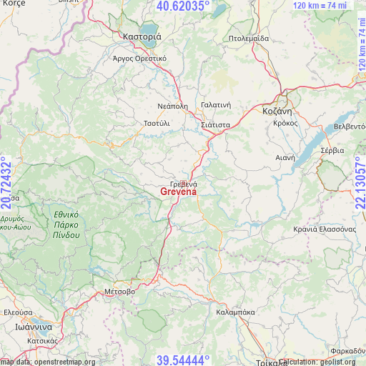
| Upper-left | 40.62035°, | 20.72432° |
| Center: | 40.08452°, | 21.42744° |
| Lower-right: | 39.54444°, | 22.13057° |
| Map W x H: | 119.6×119.6 km | = 74.3×74.3mi |
| max Lat: | 41.72048° ⇑32.5% North |
| Grevená: | 40.08452° |
| min Lat: | ⇓67.5% South 34.8346° |
| min Long | Grevená | max Long |
| 19.40494° | 21.42744° | 29.59361° |
| W 15.9%⇐ | ⇒84.1% E |
Elevation
Elevation of Grevená is 534 m = 1752 ft, and this is 365.1 m = 1198 ft above average elevation for this country.
| Max E: |
1439 m = 4721 ft | 8.9% |
| Grevená | 534 m 1752 ft | |
| Avg. | 168.9 m = 554 ft | |
Min E: |
0 m = 0 ft | 91.1% |
See also: Greece elevation on elevation.city.
Geographical zone
Grevená is located in North temperate zone (between Tropic of Cancer and the Arctic Circle). Distance of this Northern Tropic circle is 1851.1 km =1150.2 mi to South.| Distance of | km | miles | from Grevená |
|---|---|---|---|
| North Pole | 5550.1 | 3448.7 | to North |
| Arctic Circle | 2944.2 | 1829.4 | to North |
| Tropic Cancer | 1851.1 | 1150.2 | to South |
| Equator | 4457 | 2769.5 | to South |


Nearby cities:
15 places around Grevená: (largest is in red/bold)
• Agiófyllo
27.1 km =16.8 mi,  155°
155°
• Agnantiá
24.3 km =15.1 mi,  172°
172°
• Aianí
34.5 km =21.4 mi,  75°
75°
• Asprokklisiá
32.9 km =20.4 mi,  142°
142°
• Dímitra
25.1 km =15.6 mi,  127°
127°
• Eláti
35.6 km =22.1 mi,  109°
109°
• Erátyra
29.6 km =18.4 mi,  14°
14°
• Galatiní
28.2 km =17.5 mi,  21°
21°
• Karperó
22.3 km =13.9 mi, 133°
• Kraniá
24.3 km =15.1 mi,  210°
210°
• Oxýneia
29.2 km =18.1 mi, 169°
• Panagía
33.1 km =20.6 mi,  194°
194°
• Samarína
34.8 km =21.6 mi,  273°
273°
• Siátista
22.1 km =13.7 mi,  26°
26°
• Tsotíli
21.5 km =13.4 mi,  336°
336°
Sources, notices
• [Note1] Compared only with cities in Greece existing in our database
• [Src1] Map data: © OpenStreetMap contributors (CC-BY-SA)
• [Src2] Other city data from geonames.org with taken over terms of usage.
• [Src3] Geographical zone / Annual Mean Temperature by Robert A. Rohde @ Wikipedia
