Vamvakiá geodata
Vamvakiá (Central Macedonia) is a populated place; located in Greece in Europe/Athens (GMT+3) time zone. With population of 530 people, there are 1742 cities with bigger population in this country. Compared to other cities in Greece, 94.8% of cities are located further ↓South; 61.3% of cities are located further ←West and 75.5% of cities have higher elevation than Vamvakiá. Note1


Vamvakiá GPS coordinates[2]
41° 5' 2.184" North, 23° 20' 45.888" East
| Map corner | latitude | longitude |
|---|---|---|
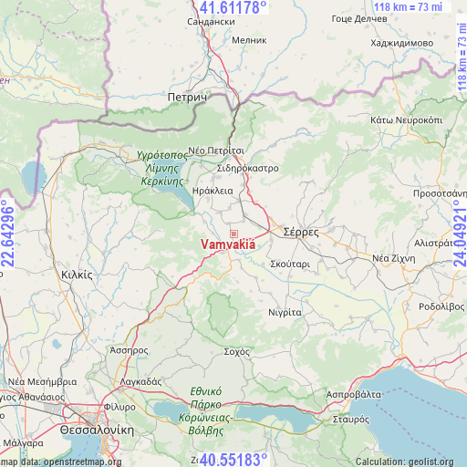
| Upper-left | 41.61178°, | 22.64296° |
| Center: | 41.08394°, | 23.34608° |
| Lower-right: | 40.55183°, | 24.04921° |
| Map W x H: | 117.9×117.9 km | = 73.3×73.3mi |
| max Lat: | 41.72048° ⇑5.2% North |
| Vamvakiá: | 41.08394° |
| min Lat: | ⇓94.8% South 34.8346° |
| min Long | Vamvakiá | max Long |
| 19.40494° | 23.34608° | 29.59361° |
| W 61.3%⇐ | ⇒38.7% E |
Elevation
Elevation of Vamvakiá is 23 m = 75 ft, and this is 145.9 m = 479 ft below average elevation for this country.
| Max E: |
1439 m = 4721 ft | 75.5% |
| Avg. | 168.9 m = 554 ft | |
| Vamvakiá | 23 m = 75 ft | |
Min E: |
0 m = 0 ft | 24.5% |
See also: Greece elevation on elevation.city.
Geographical zone
Vamvakiá is located in North temperate zone (between Tropic of Cancer and the Arctic Circle). Distance of this Northern Tropic circle is 1962.2 km =1219.3 mi to South.| Distance of | km | miles | from Vamvakiá |
|---|---|---|---|
| North Pole | 5439 | 3379.6 | to North |
| Arctic Circle | 2833.1 | 1760.4 | to North |
| Tropic Cancer | 1962.2 | 1219.3 | to South |
| Equator | 4568.1 | 2838.5 | to South |


Nearby cities:
15 places around Vamvakiá: (largest is in red/bold)
• Ammoudhiá
6.7 km =4.2 mi,  352°
352°
• Anayénnisis
3.1 km =1.9 mi,  338°
338°
• Cheímarros
7.9 km =4.9 mi,  291°
291°
• Gefyroúdi
8.5 km =5.3 mi,  8°
8°
• Kalá Déndra
6.7 km =4.2 mi,  75°
75°
• Karperí
6.4 km =4 mi,  326°
326°
• Melenikítsi
10.9 km =6.8 mi,  49°
49°
• Mitroúsi
9.7 km =6 mi,  98°
98°
• Néa Tirolóï
4.2 km =2.6 mi,  37°
37°
• Palaiókastro
9.8 km =6.1 mi,  34°
34°
• Provatás
4.1 km =2.5 mi,  115°
115°
• Skotoússa
5.8 km =3.6 mi, 31°
• Strymonikó
5.4 km =3.4 mi,  208°
208°
• Valteró
10.8 km =6.7 mi, 348°
• Áno Kamíla
7.2 km =4.5 mi,  114°
114°
Sources, notices
• [Note1] Compared only with cities in Greece existing in our database
• [Src1] Map data: © OpenStreetMap contributors (CC-BY-SA)
• [Src2] Other city data from geonames.org with taken over terms of usage.
• [Src3] Geographical zone / Annual Mean Temperature by Robert A. Rohde @ Wikipedia
