Provatás geodata
Provatás (Central Macedonia) is a populated place; located in Greece in Europe/Athens (GMT+3) time zone. With population of 1,099 people, there are 919 cities with bigger population in this country. Compared to other cities in Greece, 94.3% of cities are located further ↓South; 62.2% of cities are located further ←West and 76.1% of cities have higher elevation than Provatás. Note1


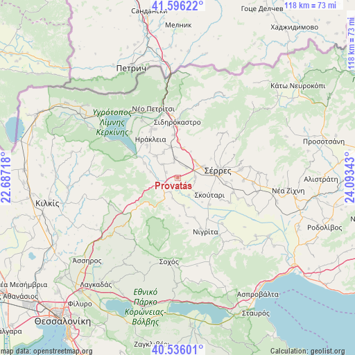
Provatás GPS coordinates[2]
41° 4' 5.7" North, 23° 23' 25.08" East
| Map corner | latitude | longitude |
|---|---|---|
| Upper-left | 41.59622°, | 22.68718° |
| Center: | 41.06825°, | 23.3903° |
| Lower-right: | 40.53601°, | 24.09343° |
| Map W x H: | 117.9×117.9 km | = 73.3×73.3mi |
| max Lat: | 41.72048° ⇑5.7% North |
| Provatás: | 41.06825° |
| min Lat: | ⇓94.3% South 34.8346° |
| min Long | Provatás | max Long |
| 19.40494° | 23.3903° | 29.59361° |
| W 62.2%⇐ | ⇒37.8% E |
Elevation
Elevation of Provatás is 22 m = 72 ft, and this is 146.9 m = 482 ft below average elevation for this country.
| Max E: |
1439 m = 4721 ft | 76.1% |
| Avg. | 168.9 m = 554 ft | |
| Provatás | 22 m = 72 ft | |
Min E: |
0 m = 0 ft | 23.9% |
See also: Greece elevation on elevation.city.
Geographical zone
Provatás is located in North temperate zone (between Tropic of Cancer and the Arctic Circle). Distance of this Northern Tropic circle is 1960.4 km =1218.1 mi to South.| Distance of | km | miles | from Provatás |
|---|---|---|---|
| North Pole | 5440.7 | 3380.7 | to North |
| Arctic Circle | 2834.8 | 1761.5 | to North |
| Tropic Cancer | 1960.4 | 1218.1 | to South |
| Equator | 4566.4 | 2837.4 | to South |


Nearby cities:
15 places around Provatás: (largest is in red/bold)
• Ammoudhiá
9.5 km =5.9 mi,  331°
331°
• Anayénnisis
6.7 km =4.2 mi,  313°
313°
• Dimitrítsi
9.4 km =5.8 mi,  168°
168°
• Kalá Déndra
4.5 km =2.8 mi,  39°
39°
• Káto Kamíla
9.4 km =5.8 mi,  123°
123°
• Lefkónas
9.6 km =6 mi,  68°
68°
• Melenikítsi
10 km =6.2 mi,  27°
27°
• Mitroúsi
5.9 km =3.7 mi,  87°
87°
• Néa Tirolóï
5.2 km =3.2 mi,  347°
347°
• Palaiókastro
10 km =6.2 mi,  11°
11°
• Skotoússa
6.7 km =4.2 mi, 353°
• Strymonikó
7 km =4.3 mi,  244°
244°
• Triantafylliá
10 km =6.2 mi,  200°
200°
• Vamvakiá
4.1 km =2.5 mi,  295°
295°
• Áno Kamíla
3.1 km =1.9 mi,  114°
114°
Sources, notices
• [Note1] Compared only with cities in Greece existing in our database
• [Src1] Map data: © OpenStreetMap contributors (CC-BY-SA)
• [Src2] Other city data from geonames.org with taken over terms of usage.
• [Src3] Geographical zone / Annual Mean Temperature by Robert A. Rohde @ Wikipedia
