Strymonikó geodata
Strymonikó (Central Macedonia) is a populated place; located in Greece in Europe/Athens (GMT+3) time zone. With population of 1,619 people, there are 617 cities with bigger population in this country. Compared to other cities in Greece, 93.7% of cities are located further ↓South; 60.6% of cities are located further ←West and 63.2% of cities have higher elevation than Strymonikó. Note1
Administrative division(s):
- Level 1: Central Macedonia
- Level 2: Nomós Serrón
- Level 3: Dimos Irakleia


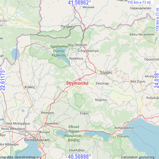
Strymonikó GPS coordinates[2]
41° 2' 29.184" North, 23° 18' 53.532" East
| Map corner | latitude | longitude |
|---|---|---|
| Upper-left | 41.56962°, | 22.61175° |
| Center: | 41.04144°, | 23.31487° |
| Lower-right: | 40.50898°, | 24.018° |
| Map W x H: | 117.9×117.9 km | = 73.3×73.3mi |
| max Lat: | 41.72048° ⇑6.3% North |
| Strymonikó: | 41.04144° |
| min Lat: | ⇓93.7% South 34.8346° |
| min Long | Strymonikó | max Long |
| 19.40494° | 23.31487° | 29.59361° |
| W 60.6%⇐ | ⇒39.4% E |
Elevation
Elevation of Strymonikó is 43 m = 141 ft, and this is 125.9 m = 413 ft below average elevation for this country.
| Max E: |
1439 m = 4721 ft | 63.2% |
| Avg. | 168.9 m = 554 ft | |
| Strymonikó | 43 m = 141 ft | |
Min E: |
0 m = 0 ft | 36.8% |
See also: Greece elevation on elevation.city.
Geographical zone
Strymonikó is located in North temperate zone (between Tropic of Cancer and the Arctic Circle). Distance of this Northern Tropic circle is 1957.5 km =1216.3 mi to South.| Distance of | km | miles | from Strymonikó |
|---|---|---|---|
| North Pole | 5443.7 | 3382.6 | to North |
| Arctic Circle | 2837.8 | 1763.3 | to North |
| Tropic Cancer | 1957.5 | 1216.3 | to South |
| Equator | 4563.4 | 2835.6 | to South |


Nearby cities:
15 places around Strymonikó: (largest is in red/bold)
• Ammoudhiá
11.4 km =7.1 mi,  8°
8°
• Anayénnisis
7.7 km =4.8 mi, 11°
• Cheímarros
9 km =5.6 mi,  328°
328°
• Dimitrítsi
10.4 km =6.5 mi,  127°
127°
• Kalá Déndra
11.2 km =7 mi,  54°
54°
• Karperí
10.1 km =6.3 mi,  355°
355°
• Lithótopos
13 km =8.1 mi,  322°
322°
• Mitroúsi
12.6 km =7.8 mi,  75°
75°
• Néa Tirolóï
9.6 km =6 mi,  32°
32°
• Provatás
7 km =4.3 mi,  64°
64°
• Skotoússa
11.2 km =7 mi, 30°
• Triantafylliá
6.9 km =4.3 mi,  156°
156°
• Vamvakiá
5.4 km =3.4 mi, 28°
• Vérgi
12 km =7.5 mi,  144°
144°
• Áno Kamíla
9.3 km =5.8 mi, 79°
Sources, notices
• [Note1] Compared only with cities in Greece existing in our database
• [Src1] Map data: © OpenStreetMap contributors (CC-BY-SA)
• [Src2] Other city data from geonames.org with taken over terms of usage.
• [Src3] Geographical zone / Annual Mean Temperature by Robert A. Rohde @ Wikipedia
