Anayénnisis geodata
Anayénnisis (Central Macedonia) is a populated place; located in Greece in Europe/Athens (GMT+3) time zone. With population of 752 people, there are 1330 cities with bigger population in this country. Compared to other cities in Greece, 95.7% of cities are located further ↓South; 60.9% of cities are located further ←West and 74.1% of cities have higher elevation than Anayénnisis. Note1


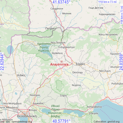
Anayénnisis GPS coordinates[2]
41° 6' 35.352" North, 23° 19' 57.216" East
| Map corner | latitude | longitude |
|---|---|---|
| Upper-left | 41.63745°, | 22.62944° |
| Center: | 41.10982°, | 23.33256° |
| Lower-right: | 40.57791°, | 24.03569° |
| Map W x H: | 117.8×117.8 km | = 73.2×73.2mi |
| max Lat: | 41.72048° ⇑4.3% North |
| Anayénnisis: | 41.10982° |
| min Lat: | ⇓95.7% South 34.8346° |
| min Long | Anayénnisis | max Long |
| 19.40494° | 23.33256° | 29.59361° |
| W 60.9%⇐ | ⇒39.1% E |
Elevation
Elevation of Anayénnisis is 25 m = 82 ft, and this is 143.9 m = 472 ft below average elevation for this country.
| Max E: |
1439 m = 4721 ft | 74.1% |
| Avg. | 168.9 m = 554 ft | |
| Anayénnisis | 25 m = 82 ft | |
Min E: |
0 m = 0 ft | 25.9% |
See also: Greece elevation on elevation.city.
Geographical zone
Anayénnisis is located in North temperate zone (between Tropic of Cancer and the Arctic Circle). Distance of this Northern Tropic circle is 1965.1 km =1221.1 mi to South.| Distance of | km | miles | from Anayénnisis |
|---|---|---|---|
| North Pole | 5436.1 | 3377.8 | to North |
| Arctic Circle | 2830.2 | 1758.6 | to North |
| Tropic Cancer | 1965.1 | 1221.1 | to South |
| Equator | 4571 | 2840.3 | to South |


Nearby cities:
15 places around Anayénnisis: (largest is in red/bold)
• Ammoudhiá
3.7 km =2.3 mi,  3°
3°
• Cheímarros
6.2 km =3.9 mi,  270°
270°
• Dasochóri
8 km =5 mi,  317°
317°
• Gefyroúdi
6 km =3.7 mi,  23°
23°
• Irákleia
9.1 km =5.7 mi,  332°
332°
• Kalá Déndra
7.7 km =4.8 mi,  98°
98°
• Karperí
3.4 km =2.1 mi, 316°
• Néa Tirolóï
3.7 km =2.3 mi,  83°
83°
• Palaiókastro
8.5 km =5.3 mi,  52°
52°
• Provatás
6.7 km =4.2 mi,  133°
133°
• Skotoússa
4.6 km =2.9 mi,  63°
63°
• Strymonikó
7.7 km =4.8 mi,  191°
191°
• Valteró
7.8 km =4.8 mi,  352°
352°
• Vamvakiá
3.1 km =1.9 mi,  158°
158°
• Vamvakófyto
9.4 km =5.8 mi,  34°
34°
Sources, notices
• [Note1] Compared only with cities in Greece existing in our database
• [Src1] Map data: © OpenStreetMap contributors (CC-BY-SA)
• [Src2] Other city data from geonames.org with taken over terms of usage.
• [Src3] Geographical zone / Annual Mean Temperature by Robert A. Rohde @ Wikipedia
