Kormísta geodata
Kormísta (Central Macedonia) is a populated place; located in Greece in Europe/Athens (GMT+3) time zone. With population of 555 people, there are 1693 cities with bigger population in this country. Compared to other cities in Greece, 91.2% of cities are located further ↓South; 79.7% of cities are located further ←West and 77.2% of cities have lower elevation than Kormísta. Note1
Administrative division(s):
- Level 1: Central Macedonia
- Level 2: Nomós Serrón
- Level 3: Dimos Amfipoli


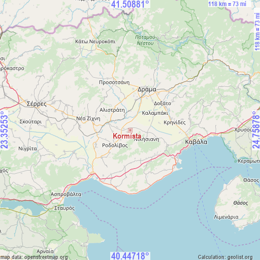
Kormísta GPS coordinates[2]
40° 58' 48.468" North, 24° 3' 20.34" East
| Map corner | latitude | longitude |
|---|---|---|
| Upper-left | 41.50881°, | 23.35253° |
| Center: | 40.98013°, | 24.05565° |
| Lower-right: | 40.44718°, | 24.75878° |
| Map W x H: | 118×118 km | = 73.3×73.3mi |
| max Lat: | 41.72048° ⇑8.8% North |
| Kormísta: | 40.98013° |
| min Lat: | ⇓91.2% South 34.8346° |
| min Long | Kormísta | max Long |
| 19.40494° | 24.05565° | 29.59361° |
| W 79.7%⇐ | ⇒20.3% E |
Elevation
Elevation of Kormísta is 234 m = 768 ft, and this is 65.1 m = 214 ft above average elevation for this country.
| Max E: |
1439 m = 4721 ft | 22.8% |
| Kormísta | 234 m 768 ft | |
| Avg. | 168.9 m = 554 ft | |
Min E: |
0 m = 0 ft | 77.2% |
See also: Greece elevation on elevation.city.
Geographical zone
Kormísta is located in North temperate zone (between Tropic of Cancer and the Arctic Circle). Distance of this Northern Tropic circle is 1950.6 km =1212 mi to South.| Distance of | km | miles | from Kormísta |
|---|---|---|---|
| North Pole | 5450.5 | 3386.8 | to North |
| Arctic Circle | 2844.6 | 1767.6 | to North |
| Tropic Cancer | 1950.6 | 1212 | to South |
| Equator | 4556.6 | 2831.3 | to South |


Nearby cities:
15 places around Kormísta: (largest is in red/bold)
• Alistráti
12.5 km =7.8 mi,  318°
318°
• Antifílippoi
13.6 km =8.5 mi,  106°
106°
• Fotolívos
8.9 km =5.5 mi,  355°
355°
• Georgianí
8.2 km =5.1 mi, 108°
• Kalampáki
13.2 km =8.2 mi,  54°
54°
• Kalós Agrós
14.2 km =8.8 mi,  10°
10°
• Krinída
6.2 km =3.9 mi,  285°
285°
• Mousthéni
13.9 km =8.6 mi,  159°
159°
• Nikísiani
8.2 km =5.1 mi,  116°
116°
• Néa Báfra
3.1 km =1.9 mi, 287°
• Palaiochóri
11 km =6.8 mi, 111°
• Platanótopos
14.8 km =9.2 mi,  178°
178°
• Próti
6.1 km =3.8 mi,  228°
228°
• Rodolívos
9.5 km =5.9 mi, 225°
• Sitagroí
14.7 km =9.1 mi,  350°
350°
Sources, notices
• [Note1] Compared only with cities in Greece existing in our database
• [Src1] Map data: © OpenStreetMap contributors (CC-BY-SA)
• [Src2] Other city data from geonames.org with taken over terms of usage.
• [Src3] Geographical zone / Annual Mean Temperature by Robert A. Rohde @ Wikipedia
