Kalamotó geodata
Kalamotó (Central Macedonia) is a populated place; located in Greece in Europe/Athens (GMT+3) time zone. With population of 871 people, there are 1170 cities with bigger population in this country. Compared to other cities in Greece, 76.3% of cities are located further ↓South; 61.7% of cities are located further ←West and 75.5% of cities have lower elevation than Kalamotó. Note1
Administrative division(s):
- Level 1: Central Macedonia
- Level 2: Nomós Thessaloníkis
- Level 3: Dimos Lagkadas


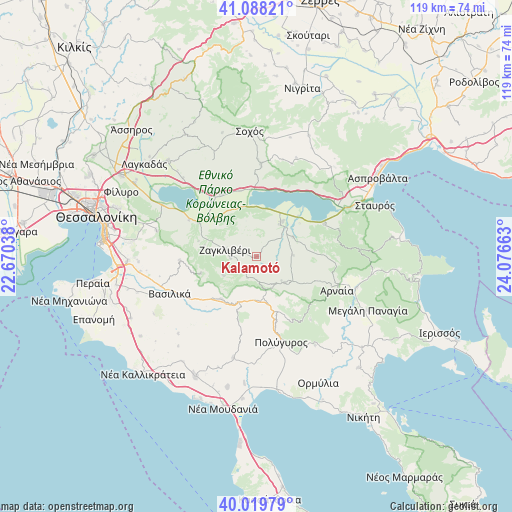
Kalamotó GPS coordinates[2]
40° 33' 22.068" North, 23° 22' 24.6" East
| Map corner | latitude | longitude |
|---|---|---|
| Upper-left | 41.08821°, | 22.67038° |
| Center: | 40.55613°, | 23.3735° |
| Lower-right: | 40.01979°, | 24.07663° |
| Map W x H: | 118.8×118.8 km | = 73.8×73.8mi |
| max Lat: | 41.72048° ⇑23.7% North |
| Kalamotó: | 40.55613° |
| min Lat: | ⇓76.3% South 34.8346° |
| min Long | Kalamotó | max Long |
| 19.40494° | 23.3735° | 29.59361° |
| W 61.7%⇐ | ⇒38.3% E |
Elevation
Elevation of Kalamotó is 216 m = 709 ft, and this is 47.1 m = 155 ft above average elevation for this country.
| Max E: |
1439 m = 4721 ft | 24.5% |
| Kalamotó | 216 m 709 ft | |
| Avg. | 168.9 m = 554 ft | |
Min E: |
0 m = 0 ft | 75.5% |
See also: Greece elevation on elevation.city.
Geographical zone
Kalamotó is located in North temperate zone (between Tropic of Cancer and the Arctic Circle). Distance of this Northern Tropic circle is 1903.5 km =1182.8 mi to South.| Distance of | km | miles | from Kalamotó |
|---|---|---|---|
| North Pole | 5497.6 | 3416 | to North |
| Arctic Circle | 2891.8 | 1796.9 | to North |
| Tropic Cancer | 1903.5 | 1182.8 | to South |
| Equator | 4509.4 | 2802 | to South |


Nearby cities:
15 places around Kalamotó: (largest is in red/bold)
• Arnaía
20.3 km =12.6 mi,  112°
112°
• Askós
21.7 km =13.5 mi,  3°
3°
• Galátista
12.6 km =7.8 mi,  218°
218°
• Gerakaroú
15.5 km =9.6 mi,  300°
300°
• Lagkadikia
13.9 km =8.6 mi,  309°
309°
• Nikomidinó
12.2 km =7.6 mi,  317°
317°
• Néa Apollonía
9.6 km =6 mi,  36°
36°
• Palaiochóra
9 km =5.6 mi,  133°
133°
• Peristerá
17.6 km =10.9 mi,  267°
267°
• Polýgyros
20.7 km =12.9 mi,  163°
163°
• Profítis
16.7 km =10.4 mi,  330°
330°
• Stanós
18.3 km =11.4 mi,  93°
93°
• Stívos
12 km =7.5 mi, 330°
• Taxiárchis
19.3 km =12 mi,  139°
139°
• Vasiloúdi
17.6 km =10.9 mi, 298°
Sources, notices
• [Note1] Compared only with cities in Greece existing in our database
• [Src1] Map data: © OpenStreetMap contributors (CC-BY-SA)
• [Src2] Other city data from geonames.org with taken over terms of usage.
• [Src3] Geographical zone / Annual Mean Temperature by Robert A. Rohde @ Wikipedia
