Cheímarros geodata
Cheímarros (Central Macedonia) is a populated place; located in Greece in Europe/Athens (GMT+3) time zone. With population of 740 people, there are 1348 cities with bigger population in this country. Compared to other cities in Greece, 95.7% of cities are located further ↓South; 59.5% of cities are located further ←West and 64.6% of cities have higher elevation than Cheímarros. Note1
Administrative division(s):
- Level 1: Central Macedonia
- Level 2: Nomós Serrón
- Level 3: Dimos Irakleia


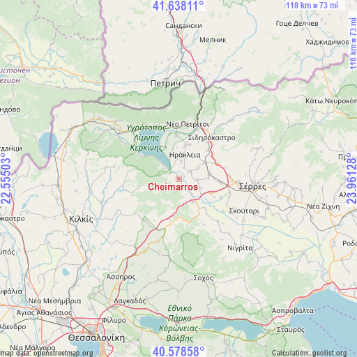
Cheímarros GPS coordinates[2]
41° 6' 37.728" North, 23° 15' 29.34" East
| Map corner | latitude | longitude |
|---|---|---|
| Upper-left | 41.63811°, | 22.55503° |
| Center: | 41.11048°, | 23.25815° |
| Lower-right: | 40.57858°, | 23.96128° |
| Map W x H: | 117.8×117.8 km | = 73.2×73.2mi |
| max Lat: | 41.72048° ⇑4.3% North |
| Cheímarros: | 41.11048° |
| min Lat: | ⇓95.7% South 34.8346° |
| min Long | Cheímarros | max Long |
| 19.40494° | 23.25815° | 29.59361° |
| W 59.5%⇐ | ⇒40.5% E |
Elevation
Elevation of Cheímarros is 40 m = 131 ft, and this is 128.9 m = 423 ft below average elevation for this country.
| Max E: |
1439 m = 4721 ft | 64.6% |
| Avg. | 168.9 m = 554 ft | |
| Cheímarros | 40 m = 131 ft | |
Min E: |
0 m = 0 ft | 35.4% |
See also: Greece elevation on elevation.city.
Geographical zone
Cheímarros is located in North temperate zone (between Tropic of Cancer and the Arctic Circle). Distance of this Northern Tropic circle is 1965.1 km =1221.1 mi to South.| Distance of | km | miles | from Cheímarros |
|---|---|---|---|
| North Pole | 5436 | 3377.8 | to North |
| Arctic Circle | 2830.1 | 1758.5 | to North |
| Tropic Cancer | 1965.1 | 1221.1 | to South |
| Equator | 4571.1 | 2840.3 | to South |


Nearby cities:
15 places around Cheímarros: (largest is in red/bold)
• Ammoudhiá
7.4 km =4.6 mi,  60°
60°
• Anayénnisis
6.2 km =3.9 mi,  90°
90°
• Chrysochórafa
8.1 km =5 mi,  346°
346°
• Dasochóri
5.9 km =3.7 mi,  7°
7°
• Gefyroúdi
10.2 km =6.3 mi, 57°
• Irákleia
8.2 km =5.1 mi, 14°
• Karperí
4.6 km =2.9 mi, 58°
• Limnochóri
11.5 km =7.1 mi,  337°
337°
• Lithótopos
4.1 km =2.5 mi,  310°
310°
• Néa Tirolóï
9.9 km =6.2 mi, 87°
• Pontisméno
11.1 km =6.9 mi, 10°
• Skotoússa
10.5 km =6.5 mi,  79°
79°
• Strymonikó
9 km =5.6 mi,  148°
148°
• Valteró
9.2 km =5.7 mi,  34°
34°
• Vamvakiá
7.9 km =4.9 mi,  111°
111°
Sources, notices
• [Note1] Compared only with cities in Greece existing in our database
• [Src1] Map data: © OpenStreetMap contributors (CC-BY-SA)
• [Src2] Other city data from geonames.org with taken over terms of usage.
• [Src3] Geographical zone / Annual Mean Temperature by Robert A. Rohde @ Wikipedia
