Kalampáki geodata
Kalampáki (East Macedonia and Thrace) is a seat of a third-order administrative division; located in Greece in Europe/Athens (GMT+3) time zone. With population of 3,514 people, there are 304 cities with bigger population in this country. Compared to other cities in Greece, 93.8% of cities are located further ↓South; 81% of cities are located further ←West and 54.3% of cities have higher elevation than Kalampáki. Note1
Administrative division(s):
- Level 1: East Macedonia and Thrace
- Level 2: Nomós Drámas
- Level 3: Dimos Doxato


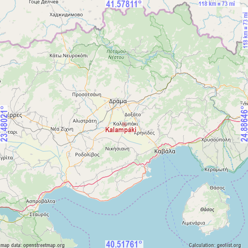
Kalampáki GPS coordinates[2]
41° 3' 0" North, 24° 10' 59.988" East
| Map corner | latitude | longitude |
|---|---|---|
| Upper-left | 41.57811°, | 23.48021° |
| Center: | 41.05°, | 24.18333° |
| Lower-right: | 40.51761°, | 24.88646° |
| Map W x H: | 117.9×117.9 km | = 73.3×73.3mi |
| max Lat: | 41.72048° ⇑6.2% North |
| Kalampáki: | 41.05° |
| min Lat: | ⇓93.8% South 34.8346° |
| min Long | Kalampáki | max Long |
| 19.40494° | 24.18333° | 29.59361° |
| W 81%⇐ | ⇒19% E |
Elevation
Elevation of Kalampáki is 67 m = 220 ft, and this is 101.9 m = 334 ft below average elevation for this country.
| Max E: |
1439 m = 4721 ft | 54.3% |
| Avg. | 168.9 m = 554 ft | |
| Kalampáki | 67 m = 220 ft | |
Min E: |
0 m = 0 ft | 45.7% |
See also: Greece elevation on elevation.city.
Geographical zone
Kalampáki is located in North temperate zone (between Tropic of Cancer and the Arctic Circle). Distance of this Northern Tropic circle is 1958.4 km =1216.9 mi to South.| Distance of | km | miles | from Kalampáki |
|---|---|---|---|
| North Pole | 5442.7 | 3381.9 | to North |
| Arctic Circle | 2836.8 | 1762.7 | to North |
| Tropic Cancer | 1958.4 | 1216.9 | to South |
| Equator | 4564.3 | 2836.1 | to South |


Nearby cities:
15 places around Kalampáki: (largest is in red/bold)
• Antifílippoi
11.8 km =7.3 mi,  168°
168°
• Choristí
9.2 km =5.7 mi,  13°
13°
• Dráma
11.8 km =7.3 mi,  345°
345°
• Fotolívos
11.5 km =7.1 mi,  275°
275°
• Fteliá
3.7 km =2.3 mi, 8°
• Fílippoi
13.4 km =8.3 mi,  101°
101°
• Georgianí
10.8 km =6.7 mi,  195°
195°
• Kalós Agrós
10.2 km =6.3 mi,  306°
306°
• Kormísta
13.2 km =8.2 mi,  234°
234°
• Krinídes
10.3 km =6.4 mi,  112°
112°
• Kýria
10.4 km =6.5 mi,  58°
58°
• Lydía
8.5 km =5.3 mi, 104°
• Nikísiani
11.9 km =7.4 mi, 196°
• Palaiochóri
11.9 km =7.4 mi,  182°
182°
• Ágios Athanásios
5.9 km =3.7 mi, 62°
Sources, notices
• [Note1] Compared only with cities in Greece existing in our database
• [Src1] Map data: © OpenStreetMap contributors (CC-BY-SA)
• [Src2] Other city data from geonames.org with taken over terms of usage.
• [Src3] Geographical zone / Annual Mean Temperature by Robert A. Rohde @ Wikipedia
