San Juan Ixcoy geodata
San Juan Ixcoy (Huehuetenango) is a seat of a second-order administrative division; located in Guatemala in America/Guatemala (GMT-6) time zone. With population of 2,535 people, there are 260 cities with bigger population in this country. Compared to other cities in Guatemala, 89.7% of cities are located further ↓South; 68.4% of cities are located further →East and 82.9% of cities have lower elevation than San Juan Ixcoy. Note1


San Juan Ixcoy GPS coordinates[2]
15° 36' 0.792" North, 91° 26' 47.004" West
| Map corner | latitude | longitude |
|---|---|---|
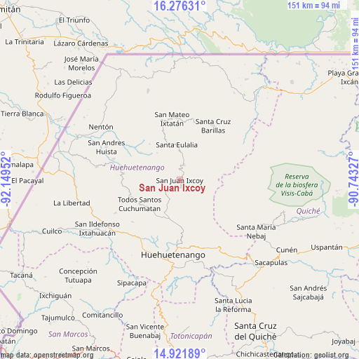
| Upper-left | 16.27631°, | -92.14952° |
| Center: | 15.60022°, | -91.44639° |
| Lower-right: | 14.92189°, | -90.74327° |
| Map W x H: | 150.6×150.6 km | = 93.6×93.6mi |
| max Lat: | 17.06606° ⇑10.3% North |
| San Juan Ixcoy: | 15.60022° |
| min Lat: | ⇓89.7% South 13.9274° |
| min Long | San Juan Ixcoy | max Long |
| -92.19298° | -91.44639° | -88.59444° |
| W 31.6%⇐ | ⇒68.4% E |
Elevation
Elevation of San Juan Ixcoy is 2185 m = 7169 ft, and this is 918 m = 3012 ft above average elevation for this country.
| Max E: |
3254 m = 10676 ft | 17.1% |
| San Juan Ixcoy | 2185 m 7169 ft | |
| Avg. | 1267 m = 4157 ft | |
Min E: |
1 m = 3 ft | 82.9% |
See also: Guatemala elevation on elevation.city.
Geographical zone
San Juan Ixcoy is located in North Torrid zone (between Equator and Tropic of Cancer). Distance of this Northern Tropic circle is 871.3 km =541.4 mi to North.| Distance of | km | miles | from San Juan Ixcoy |
|---|---|---|---|
| North Pole | 8272.5 | 5140.3 | to North |
| Arctic Circle | 5666.6 | 3521.1 | to North |
| Tropic Cancer | 871.3 | 541.4 | to North |
| Equator | 1734.6 | 1077.8 | to South |


Nearby cities:
15 places around San Juan Ixcoy: (largest is in red/bold)
• Barillas
26.6 km =16.5 mi,  31°
31°
• Chiantla
27.3 km =17 mi,  182°
182°
• Concepción Huista
23.6 km =14.7 mi,  276°
276°
• Huehuetenango
31.4 km =19.5 mi,  185°
185°
• Jacaltenango
29.4 km =18.3 mi, 284°
• San Juan Atitán
26.9 km =16.7 mi,  224°
224°
• San Mateo Ixtatán
26 km =16.2 mi,  352°
352°
• San Miguel Acatán
19.9 km =12.4 mi,  305°
305°
• San Rafael La Independencia
14.8 km =9.2 mi,  319°
319°
• San Sebastián Coatán
19.6 km =12.2 mi, 320°
• San Sebastián Huehuetenango
29.8 km =18.5 mi, 217°
• Santa Eulalia
14.6 km =9.1 mi, 354°
• Santiago Chimaltenango
30.1 km =18.7 mi,  242°
242°
• Soloma
6.7 km =4.2 mi,  15°
15°
• Todos Santos Cuchumatán
19.7 km =12.2 mi, 238°
Sources, notices
• [Note1] Compared only with cities in Guatemala existing in our database
• [Src1] Map data: © OpenStreetMap contributors (CC-BY-SA)
• [Src2] Other city data from geonames.org with taken over terms of usage.
• [Src3] Geographical zone / Annual Mean Temperature by Robert A. Rohde @ Wikipedia
