San Martín Jilotepeque geodata
San Martín Jilotepeque (Chimaltenango) is a seat of a second-order administrative division; located in Guatemala in America/Guatemala (GMT-6) time zone. With population of 9,846 people, there are 130 cities with bigger population in this country. Compared to other cities in Guatemala, 52.2% of cities are located further ↑North; 55.8% of cities are located further ←West and 67.3% of cities have lower elevation than San Martín Jilotepeque. Note1


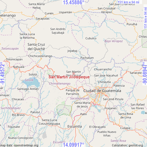
San Martín Jilotepeque GPS coordinates[2]
14° 46' 48.288" North, 90° 47' 33.324" West
| Map corner | latitude | longitude |
|---|---|---|
| Upper-left | 15.45886°, | -91.49572° |
| Center: | 14.78008°, | -90.79259° |
| Lower-right: | 14.09917°, | -90.08947° |
| Map W x H: | 151.2×151.2 km | = 94×94mi |
| max Lat: | 17.06606° ⇑52.2% North |
| San Martín Jilotepeque: | 14.78008° |
| min Lat: | ⇓47.8% South 13.9274° |
| min Long | San Martín Jil | max Long |
| -92.19298° | -90.79259° | -88.59444° |
| W 55.8%⇐ | ⇒44.2% E |
Elevation
Elevation of San Martín Jilotepeque is 1728 m = 5669 ft, and this is 461 m = 1512 ft above average elevation for this country.
| Max E: |
3254 m = 10676 ft | 32.7% |
| San Martín Jilotepeque | 1728 m 5669 ft | |
| Avg. | 1267 m = 4157 ft | |
Min E: |
1 m = 3 ft | 67.3% |
See also: Guatemala elevation on elevation.city.
Geographical zone
San Martín Jilotepeque is located in North Torrid zone (between Equator and Tropic of Cancer). Distance of this Northern Tropic circle is 962.5 km =598.1 mi to North.| Distance of | km | miles | from San Martín Jilotepeque |
|---|---|---|---|
| North Pole | 8363.7 | 5197 | to North |
| Arctic Circle | 5757.8 | 3577.7 | to North |
| Tropic Cancer | 962.5 | 598.1 | to North |
| Equator | 1643.4 | 1021.2 | to South |


Nearby cities:
15 places around San Martín Jilotepeque: (largest is in red/bold)
• Chimaltenango
13.5 km =8.4 mi,  192°
192°
• Comalapa
11.1 km =6.9 mi,  246°
246°
• El Tejar
14.8 km =9.2 mi,  179°
179°
• Parramos
19.1 km =11.9 mi, 183°
• Pastores
21.1 km =13.1 mi,  168°
168°
• San Andrés Itzapa
18.4 km =11.4 mi,  197°
197°
• San José Poaquil
13.6 km =8.5 mi,  288°
288°
• San Juan Sacatepéquez
17.3 km =10.7 mi,  113°
113°
• San Pedro Sacatepéquez
19.2 km =11.9 mi,  122°
122°
• Santa Apolonia
19.4 km =12.1 mi,  273°
273°
• Santa Cruz Balanyá
17.2 km =10.7 mi,  232°
232°
• Santiago Sacatepéquez
20.4 km =12.7 mi,  142°
142°
• Santo Domingo Xenacoj
14.9 km =9.3 mi, 138°
• Sumpango
16.2 km =10.1 mi,  157°
157°
• Zaragoza
17.9 km =11.1 mi,  215°
215°
Sources, notices
• [Note1] Compared only with cities in Guatemala existing in our database
• [Src1] Map data: © OpenStreetMap contributors (CC-BY-SA)
• [Src2] Other city data from geonames.org with taken over terms of usage.
• [Src3] Geographical zone / Annual Mean Temperature by Robert A. Rohde @ Wikipedia
