Comalapa geodata
Comalapa (Chimaltenango) is a seat of a second-order administrative division; located in Guatemala in America/Guatemala (GMT-6) time zone. With population of 20,738 people, there are 51 cities with bigger population in this country. Compared to other cities in Guatemala, 56.6% of cities are located further ↑North; 51.9% of cities are located further ←West and 80.5% of cities have lower elevation than Comalapa. Note1


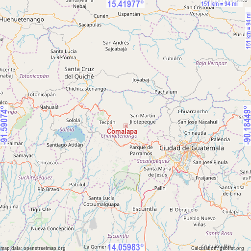
Comalapa GPS coordinates[2]
14° 44' 27.096" North, 90° 53' 15.396" West
| Map corner | latitude | longitude |
|---|---|---|
| Upper-left | 15.41977°, | -91.59074° |
| Center: | 14.74086°, | -90.88761° |
| Lower-right: | 14.05983°, | -90.18449° |
| Map W x H: | 151.2×151.2 km | = 94×94mi |
| max Lat: | 17.06606° ⇑56.6% North |
| Comalapa: | 14.74086° |
| min Lat: | ⇓43.4% South 13.9274° |
| min Long | Comalapa | max Long |
| -92.19298° | -90.88761° | -88.59444° |
| W 51.9%⇐ | ⇒48.1% E |
Elevation
Elevation of Comalapa is 2115 m = 6939 ft, and this is 848 m = 2782 ft above average elevation for this country.
| Max E: |
3254 m = 10676 ft | 19.5% |
| Comalapa | 2115 m 6939 ft | |
| Avg. | 1267 m = 4157 ft | |
Min E: |
1 m = 3 ft | 80.5% |
See also: Guatemala elevation on elevation.city.
Geographical zone
Comalapa is located in North Torrid zone (between Equator and Tropic of Cancer). Distance of this Northern Tropic circle is 966.9 km =600.8 mi to North.| Distance of | km | miles | from Comalapa |
|---|---|---|---|
| North Pole | 8368 | 5199.6 | to North |
| Arctic Circle | 5762.1 | 3580.4 | to North |
| Tropic Cancer | 966.9 | 600.8 | to North |
| Equator | 1639 | 1018.4 | to South |


Nearby cities:
15 places around Comalapa: (largest is in red/bold)
• Acatenango
21.6 km =13.4 mi,  196°
196°
• Chimaltenango
11.5 km =7.1 mi,  140°
140°
• El Tejar
14.7 km =9.1 mi, 135°
• Parramos
17.3 km =10.7 mi,  148°
148°
• Patzicía
12.8 km =8 mi, 199°
• Patzún
15.1 km =9.4 mi,  244°
244°
• San Andrés Itzapa
14 km =8.7 mi,  160°
160°
• San José Poaquil
9 km =5.6 mi,  342°
342°
• San Martín Jilotepeque
11.1 km =6.9 mi,  66°
66°
• Santa Apolonia
10.7 km =6.6 mi,  301°
301°
• Santa Cruz Balanyá
7.1 km =4.4 mi,  208°
208°
• Santo Domingo Xenacoj
21.2 km =13.2 mi,  108°
108°
• Sumpango
19.6 km =12.2 mi,  122°
122°
• Tecpán Guatemala
11.5 km =7.1 mi,  281°
281°
• Zaragoza
10.1 km =6.3 mi,  181°
181°
Sources, notices
• [Note1] Compared only with cities in Guatemala existing in our database
• [Src1] Map data: © OpenStreetMap contributors (CC-BY-SA)
• [Src2] Other city data from geonames.org with taken over terms of usage.
• [Src3] Geographical zone / Annual Mean Temperature by Robert A. Rohde @ Wikipedia
