Taxisco geodata
Taxisco (Santa Rosa) is a populated place; located in Guatemala in America/Guatemala (GMT-6) time zone. With population of 6,518 people, there are 178 cities with bigger population in this country. Compared to other cities in Guatemala, 98.5% of cities are located further ↑North; 67.8% of cities are located further ←West and 90.9% of cities have higher elevation than Taxisco. Note1


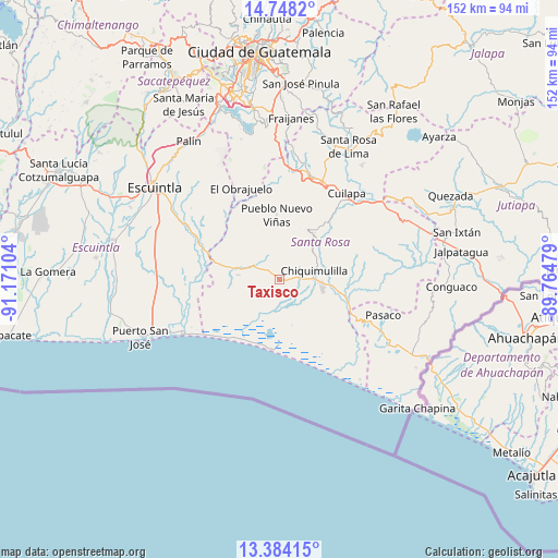
Taxisco GPS coordinates[2]
14° 4' 1.884" North, 90° 28' 4.476" West
| Map corner | latitude | longitude |
|---|---|---|
| Upper-left | 14.7482°, | -91.17104° |
| Center: | 14.06719°, | -90.46791° |
| Lower-right: | 13.38415°, | -89.76479° |
| Map W x H: | 151.7×151.7 km | = 94.3×94.3mi |
| max Lat: | 17.06606° ⇑98.5% North |
| Taxisco: | 14.06719° |
| min Lat: | ⇓1.5% South 13.9274° |
| min Long | Taxisco | max Long |
| -92.19298° | -90.46791° | -88.59444° |
| W 67.8%⇐ | ⇒32.2% E |
Elevation
Elevation of Taxisco is 180 m = 591 ft, and this is 1087 m = 3566 ft below average elevation for this country.
| Max E: |
3254 m = 10676 ft | 90.9% |
| Avg. | 1267 m = 4157 ft | |
| Taxisco | 180 m = 591 ft | |
Min E: |
1 m = 3 ft | 9.1% |
See also: Guatemala elevation on elevation.city.
Geographical zone
Taxisco is located in North Torrid zone (between Equator and Tropic of Cancer). Distance of this Northern Tropic circle is 1041.8 km =647.3 mi to North.| Distance of | km | miles | from Taxisco |
|---|---|---|---|
| North Pole | 8442.9 | 5246.2 | to North |
| Arctic Circle | 5837 | 3626.9 | to North |
| Tropic Cancer | 1041.8 | 647.3 | to North |
| Equator | 1564.1 | 971.9 | to South |


Nearby cities:
15 places around Taxisco: (largest is in red/bold)
• Barberena
29.1 km =18.1 mi,  23°
23°
• Chiquimulilla
9.1 km =5.7 mi,  78°
78°
• Cuilapa
29.5 km =18.3 mi,  38°
38°
• Guanagazapa
25.8 km =16 mi,  312°
312°
• Guazacapán
5.6 km =3.5 mi, 82°
• Iztapa
29.8 km =18.5 mi,  240°
240°
• Nueva Santa Rosa
40.6 km =25.2 mi,  30°
30°
• Oratorio
36.2 km =22.5 mi,  60°
60°
• Pasaco
29.9 km =18.6 mi,  109°
109°
• Pueblo Nuevo Viñas
17.7 km =11 mi,  357°
357°
• Puerto San José
41.2 km =25.6 mi,  247°
247°
• San Juan Tecuaco
21.8 km =13.5 mi,  85°
85°
• Santa Cruz Naranjo
37.2 km =23.1 mi, 16°
• Santa María Ixhuatán
24.9 km =15.5 mi, 56°
• Santa Rosa de Lima
40.2 km =25 mi, 27°
Sources, notices
• [Note1] Compared only with cities in Guatemala existing in our database
• [Src1] Map data: © OpenStreetMap contributors (CC-BY-SA)
• [Src2] Other city data from geonames.org with taken over terms of usage.
• [Src3] Geographical zone / Annual Mean Temperature by Robert A. Rohde @ Wikipedia
