Guanagazapa geodata
Guanagazapa (Escuintla) is a seat of a second-order administrative division; located in Guatemala in America/Guatemala (GMT-6) time zone. With population of 2,842 people, there are 246 cities with bigger population in this country. Compared to other cities in Guatemala, 94.1% of cities are located further ↑North; 62.2% of cities are located further ←West and 81.4% of cities have higher elevation than Guanagazapa. Note1


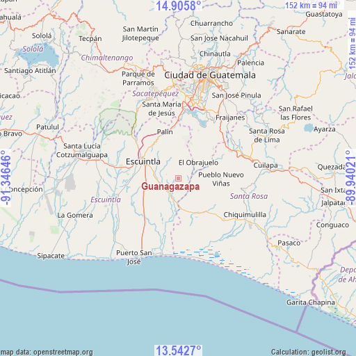
Guanagazapa GPS coordinates[2]
14° 13' 31.008" North, 90° 38' 35.988" West
| Map corner | latitude | longitude |
|---|---|---|
| Upper-left | 14.9058°, | -91.34646° |
| Center: | 14.22528°, | -90.64333° |
| Lower-right: | 13.5427°, | -89.94021° |
| Map W x H: | 151.6×151.6 km | = 94.2×94.2mi |
| max Lat: | 17.06606° ⇑94.1% North |
| Guanagazapa: | 14.22528° |
| min Lat: | ⇓5.9% South 13.9274° |
| min Long | Guanagazapa | max Long |
| -92.19298° | -90.64333° | -88.59444° |
| W 62.2%⇐ | ⇒37.8% E |
Elevation
Elevation of Guanagazapa is 345 m = 1132 ft, and this is 922 m = 3025 ft below average elevation for this country.
| Max E: |
3254 m = 10676 ft | 81.4% |
| Avg. | 1267 m = 4157 ft | |
| Guanagazapa | 345 m = 1132 ft | |
Min E: |
1 m = 3 ft | 18.6% |
See also: Guatemala elevation on elevation.city.
Geographical zone
Guanagazapa is located in North Torrid zone (between Equator and Tropic of Cancer). Distance of this Northern Tropic circle is 1024.2 km =636.4 mi to North.| Distance of | km | miles | from Guanagazapa |
|---|---|---|---|
| North Pole | 8425.4 | 5235.3 | to North |
| Arctic Circle | 5819.5 | 3616.1 | to North |
| Tropic Cancer | 1024.2 | 636.4 | to North |
| Equator | 1581.7 | 982.8 | to South |


Nearby cities:
15 places around Guanagazapa: (largest is in red/bold)
• Amatitlán
28 km =17.4 mi,  1°
1°
• Barberena
31.7 km =19.7 mi,  73°
73°
• Chiquimulilla
31.9 km =19.8 mi,  119°
119°
• Escuintla
17.7 km =11 mi,  300°
300°
• Guazacapán
29.7 km =18.5 mi, 124°
• Iztapa
33.2 km =20.6 mi,  192°
192°
• La Democracia
32.8 km =20.4 mi,  271°
271°
• Masagua
22.2 km =13.8 mi,  263°
263°
• Palín
20.6 km =12.8 mi,  343°
343°
• Petapa
32 km =19.9 mi,  15°
15°
• Pueblo Nuevo Viñas
18 km =11.2 mi,  89°
89°
• San Vicente Pacaya
21.1 km =13.1 mi, 2°
• Santa María de Jesús
30.8 km =19.1 mi,  346°
346°
• Taxisco
25.8 km =16 mi,  132°
132°
• Villa Canales
31 km =19.3 mi, 22°
Sources, notices
• [Note1] Compared only with cities in Guatemala existing in our database
• [Src1] Map data: © OpenStreetMap contributors (CC-BY-SA)
• [Src2] Other city data from geonames.org with taken over terms of usage.
• [Src3] Geographical zone / Annual Mean Temperature by Robert A. Rohde @ Wikipedia
