Puerto San José geodata
Puerto San José (Escuintla) is a populated place; located in Guatemala in America/Guatemala (GMT-6) time zone. With population of 18,655 people, there are 63 cities with bigger population in this country. Compared to other cities in Guatemala, 100% of cities are located further ↑North; 53.7% of cities are located further ←West and 99.4% of cities have higher elevation than Puerto San José. Note1


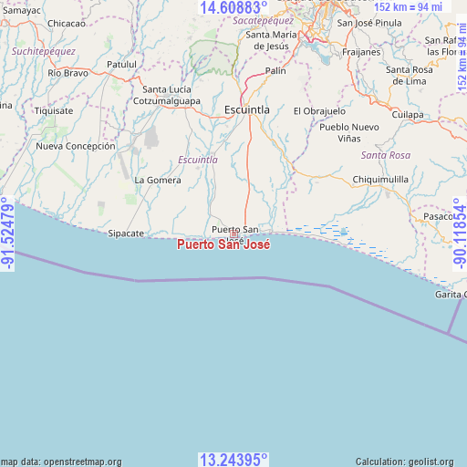
Puerto San José GPS coordinates[2]
13° 55' 38.64" North, 90° 49' 17.976" West
| Map corner | latitude | longitude |
|---|---|---|
| Upper-left | 14.60883°, | -91.52479° |
| Center: | 13.9274°, | -90.82166° |
| Lower-right: | 13.24395°, | -90.11854° |
| Map W x H: | 151.8×151.8 km | = 94.3×94.3mi |
| max Lat: | 17.06606° ⇑100% North |
| Puerto San José: | 13.9274° |
| min Lat: | ⇓0% South 13.9274° |
| min Long | Puerto San Jos� | max Long |
| -92.19298° | -90.82166° | -88.59444° |
| W 53.7%⇐ | ⇒46.3% E |
Elevation
Elevation of Puerto San José is 6 m = 20 ft, and this is 1261 m = 4137 ft below average elevation for this country.
| Max E: |
3254 m = 10676 ft | 99.4% |
| Avg. | 1267 m = 4157 ft | |
| Puerto San José | 6 m = 20 ft | |
Min E: |
1 m = 3 ft | 0.6% |
See also: Guatemala elevation on elevation.city.
Geographical zone
Puerto San José is located in North Torrid zone (between Equator and Tropic of Cancer). Distance of this Northern Tropic circle is 1057.3 km =657 mi to North.| Distance of | km | miles | from Puerto San José |
|---|---|---|---|
| North Pole | 8458.5 | 5255.9 | to North |
| Arctic Circle | 5852.6 | 3636.6 | to North |
| Tropic Cancer | 1057.3 | 657 | to North |
| Equator | 1548.6 | 962.3 | to South |


Nearby cities:
15 places around Puerto San José: (largest is in red/bold)
• Chiquimulilla
50.2 km =31.2 mi,  69°
69°
• Escuintla
42.2 km =26.2 mi,  5°
5°
• Guanagazapa
38.3 km =23.8 mi,  30°
30°
• Guazacapán
46.6 km =29 mi, 69°
• Iztapa
12.3 km =7.6 mi,  86°
86°
• La Democracia
36.4 km =22.6 mi,  338°
338°
• La Gomera
30.4 km =18.9 mi,  304°
304°
• Masagua
30.8 km =19.1 mi,  354°
354°
• Nueva Concepción
59.8 km =37.2 mi, 300°
• Palín
54.6 km =33.9 mi, 14°
• Pueblo Nuevo Viñas
49.9 km =31 mi,  48°
48°
• San Vicente Pacaya
57.8 km =35.9 mi,  20°
20°
• Santa Lucía Cotzumalguapa
50.3 km =31.3 mi,  334°
334°
• Siquinalá
44.9 km =27.9 mi, 339°
• Taxisco
41.2 km =25.6 mi, 67°
Sources, notices
• [Note1] Compared only with cities in Guatemala existing in our database
• [Src1] Map data: © OpenStreetMap contributors (CC-BY-SA)
• [Src2] Other city data from geonames.org with taken over terms of usage.
• [Src3] Geographical zone / Annual Mean Temperature by Robert A. Rohde @ Wikipedia
