Iztapa geodata
Iztapa (Escuintla) is a seat of a second-order administrative division; located in Guatemala in America/Guatemala (GMT-6) time zone. With population of 4,020 people, there are 222 cities with bigger population in this country. Compared to other cities in Guatemala, 99.7% of cities are located further ↑North; 59.3% of cities are located further ←West and 99.7% of cities have higher elevation than Iztapa. Note1


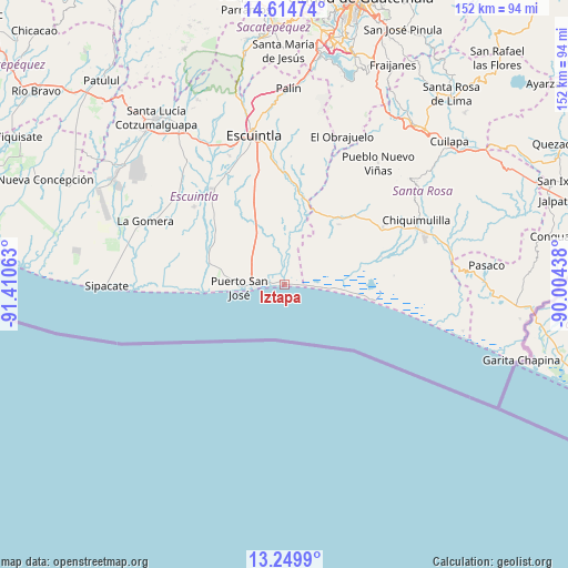
Iztapa GPS coordinates[2]
13° 55' 59.988" North, 90° 42' 27" West
| Map corner | latitude | longitude |
|---|---|---|
| Upper-left | 14.61474°, | -91.41063° |
| Center: | 13.93333°, | -90.7075° |
| Lower-right: | 13.2499°, | -90.00438° |
| Map W x H: | 151.8×151.8 km | = 94.3×94.3mi |
| max Lat: | 17.06606° ⇑99.7% North |
| Iztapa: | 13.93333° |
| min Lat: | ⇓0.3% South 13.9274° |
| min Long | Iztapa | max Long |
| -92.19298° | -90.7075° | -88.59444° |
| W 59.3%⇐ | ⇒40.7% E |
Elevation
Elevation of Iztapa is 3 m = 10 ft, and this is 1264 m = 4147 ft below average elevation for this country.
| Max E: |
3254 m = 10676 ft | 99.7% |
| Avg. | 1267 m = 4157 ft | |
| Iztapa | 3 m = 10 ft | |
Min E: |
1 m = 3 ft | 0.3% |
See also: Guatemala elevation on elevation.city.
Geographical zone
Iztapa is located in North Torrid zone (between Equator and Tropic of Cancer). Distance of this Northern Tropic circle is 1056.7 km =656.6 mi to North.| Distance of | km | miles | from Iztapa |
|---|---|---|---|
| North Pole | 8457.8 | 5255.4 | to North |
| Arctic Circle | 5851.9 | 3636.2 | to North |
| Tropic Cancer | 1056.7 | 656.6 | to North |
| Equator | 1549.2 | 962.6 | to South |


Nearby cities:
15 places around Iztapa: (largest is in red/bold)
• Chiquimulilla
38.6 km =24 mi,  64°
64°
• Escuintla
42.2 km =26.2 mi,  348°
348°
• Guanagazapa
33.2 km =20.6 mi,  12°
12°
• Guazacapán
35.1 km =21.8 mi, 63°
• La Democracia
42 km =26.1 mi,  321°
321°
• La Gomera
40.9 km =25.4 mi,  293°
293°
• Masagua
33.6 km =20.9 mi,  333°
333°
• Palín
52.3 km =32.5 mi,  1°
1°
• Pasaco
54.3 km =33.7 mi,  84°
84°
• Pueblo Nuevo Viñas
41 km =25.5 mi,  37°
37°
• Puerto San José
12.3 km =7.6 mi,  266°
266°
• San Juan Tecuaco
50.4 km =31.3 mi,  70°
70°
• San Vicente Pacaya
54.1 km =33.6 mi, 8°
• Siquinalá
49.9 km =31 mi, 326°
• Taxisco
29.8 km =18.5 mi, 60°
Sources, notices
• [Note1] Compared only with cities in Guatemala existing in our database
• [Src1] Map data: © OpenStreetMap contributors (CC-BY-SA)
• [Src2] Other city data from geonames.org with taken over terms of usage.
• [Src3] Geographical zone / Annual Mean Temperature by Robert A. Rohde @ Wikipedia
