Santa Lucia La Reforma geodata
Santa Lucia La Reforma (Totonicapán) is a seat of a second-order administrative division; located in Guatemala in America/Guatemala (GMT-6) time zone. With population of 1,406 people, there are 301 cities with bigger population in this country. Compared to other cities in Guatemala, 74% of cities are located further ↓South; 60.8% of cities are located further →East and 72.3% of cities have lower elevation than Santa Lucia La Reforma. Note1


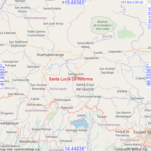
Santa Lucia La Reforma GPS coordinates[2]
15° 7' 41.484" North, 91° 14' 10.284" West
| Map corner | latitude | longitude |
|---|---|---|
| Upper-left | 15.80585°, | -91.93932° |
| Center: | 15.12819°, | -91.23619° |
| Lower-right: | 14.44836°, | -90.53307° |
| Map W x H: | 150.9×150.9 km | = 93.8×93.8mi |
| max Lat: | 17.06606° ⇑26% North |
| Santa Lucia La Reforma: | 15.12819° |
| min Lat: | ⇓74% South 13.9274° |
| min Long | Santa Lucia La | max Long |
| -92.19298° | -91.23619° | -88.59444° |
| W 39.2%⇐ | ⇒60.8% E |
Elevation
Elevation of Santa Lucia La Reforma is 1895 m = 6217 ft, and this is 628 m = 2060 ft above average elevation for this country.
| Max E: |
3254 m = 10676 ft | 27.7% |
| Santa Lucia La Reforma | 1895 m 6217 ft | |
| Avg. | 1267 m = 4157 ft | |
Min E: |
1 m = 3 ft | 72.3% |
See also: Guatemala elevation on elevation.city.
Geographical zone
Santa Lucia La Reforma is located in North Torrid zone (between Equator and Tropic of Cancer). Distance of this Northern Tropic circle is 923.8 km =574 mi to North.| Distance of | km | miles | from Santa Lucia La Reforma |
|---|---|---|---|
| North Pole | 8325 | 5172.9 | to North |
| Arctic Circle | 5719.1 | 3553.7 | to North |
| Tropic Cancer | 923.8 | 574 | to North |
| Equator | 1682.1 | 1045.2 | to South |


Nearby cities:
15 places around Santa Lucia La Reforma: (largest is in red/bold)
• Aguacatán
25.1 km =15.6 mi,  341°
341°
• Chichicastenango
24.6 km =15.3 mi,  146°
146°
• Chiché
22.8 km =14.2 mi,  125°
125°
• Chinique
24.5 km =15.2 mi,  113°
113°
• Momostenango
20.7 km =12.9 mi,  243°
243°
• Patzité
18.5 km =11.5 mi,  170°
170°
• Sacapulas
23.8 km =14.8 mi,  41°
41°
• San Antonio Ilotenango
8.2 km =5.1 mi,  175°
175°
• San Bartolo
24.1 km =15 mi,  258°
258°
• San Bartolomé Jocotenango
18.4 km =11.4 mi,  67°
67°
• San Francisco El Alto
30.1 km =18.7 mi,  227°
227°
• San Pédro Jocopilas
9.8 km =6.1 mi, 111°
• Santa Cruz del Quiché
14.3 km =8.9 mi,  139°
139°
• Santa María Chiquimula
14.8 km =9.2 mi,  222°
222°
• Totonicapán
27.6 km =17.1 mi,  209°
209°
Sources, notices
• [Note1] Compared only with cities in Guatemala existing in our database
• [Src1] Map data: © OpenStreetMap contributors (CC-BY-SA)
• [Src2] Other city data from geonames.org with taken over terms of usage.
• [Src3] Geographical zone / Annual Mean Temperature by Robert A. Rohde @ Wikipedia
