Aguacatán geodata
Aguacatán (Huehuetenango) is a seat of a second-order administrative division; located in Guatemala in America/Guatemala (GMT-6) time zone. With population of 5,572 people, there are 195 cities with bigger population in this country. Compared to other cities in Guatemala, 81.1% of cities are located further ↓South; 63.4% of cities are located further →East and 65.5% of cities have lower elevation than Aguacatán. Note1


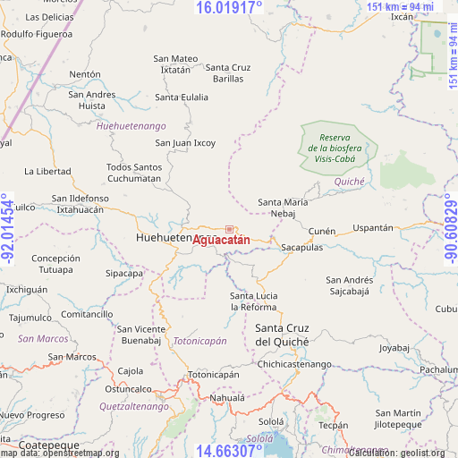
Aguacatán GPS coordinates[2]
15° 20' 31.992" North, 91° 18' 41.076" West
| Map corner | latitude | longitude |
|---|---|---|
| Upper-left | 16.01917°, | -92.01454° |
| Center: | 15.34222°, | -91.31141° |
| Lower-right: | 14.66307°, | -90.60829° |
| Map W x H: | 150.8×150.8 km | = 93.7×93.7mi |
| max Lat: | 17.06606° ⇑18.9% North |
| Aguacatán: | 15.34222° |
| min Lat: | ⇓81.1% South 13.9274° |
| min Long | Aguacatán | max Long |
| -92.19298° | -91.31141° | -88.59444° |
| W 36.6%⇐ | ⇒63.4% E |
Elevation
Elevation of Aguacatán is 1667 m = 5469 ft, and this is 400 m = 1312 ft above average elevation for this country.
| Max E: |
3254 m = 10676 ft | 34.5% |
| Aguacatán | 1667 m 5469 ft | |
| Avg. | 1267 m = 4157 ft | |
Min E: |
1 m = 3 ft | 65.5% |
See also: Guatemala elevation on elevation.city.
Geographical zone
Aguacatán is located in North Torrid zone (between Equator and Tropic of Cancer). Distance of this Northern Tropic circle is 900 km =559.2 mi to North.| Distance of | km | miles | from Aguacatán |
|---|---|---|---|
| North Pole | 8301.2 | 5158.1 | to North |
| Arctic Circle | 5695.3 | 3538.9 | to North |
| Tropic Cancer | 900 | 559.2 | to North |
| Equator | 1705.9 | 1060 | to South |


Nearby cities:
15 places around Aguacatán: (largest is in red/bold)
• Chajul
33.6 km =20.9 mi,  61°
61°
• Chiantla
15.8 km =9.8 mi,  275°
275°
• Cunén
30.4 km =18.9 mi,  91°
91°
• Huehuetenango
17.5 km =10.9 mi,  261°
261°
• Malacatancito
22.9 km =14.2 mi,  241°
241°
• Nebaj
19 km =11.8 mi,  68°
68°
• Sacapulas
24.6 km =15.3 mi,  104°
104°
• San Antonio Ilotenango
33.1 km =20.6 mi,  164°
164°
• San Bartolo
32.6 km =20.3 mi,  208°
208°
• San Bartolomé Jocotenango
30.1 km =18.7 mi,  123°
123°
• San Juan Cotzal
31.3 km =19.4 mi, 71°
• San Juan Ixcoy
32.1 km =19.9 mi,  333°
333°
• San Pédro Jocopilas
32.4 km =20.1 mi,  147°
147°
• San Sebastián Huehuetenango
33 km =20.5 mi, 278°
• Santa Lucia La Reforma
25.1 km =15.6 mi, 161°
Sources, notices
• [Note1] Compared only with cities in Guatemala existing in our database
• [Src1] Map data: © OpenStreetMap contributors (CC-BY-SA)
• [Src2] Other city data from geonames.org with taken over terms of usage.
• [Src3] Geographical zone / Annual Mean Temperature by Robert A. Rohde @ Wikipedia
