Momostenango geodata
Momostenango (Totonicapán) is a seat of a second-order administrative division; located in Guatemala in America/Guatemala (GMT-6) time zone. With population of 31,739 people, there are 34 cities with bigger population in this country. Compared to other cities in Guatemala, 69.3% of cities are located further ↓South; 66.4% of cities are located further →East and 84.1% of cities have lower elevation than Momostenango. Note1


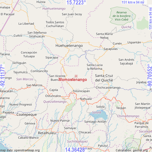
Momostenango GPS coordinates[2]
15° 2' 39.732" North, 91° 24' 31.104" West
| Map corner | latitude | longitude |
|---|---|---|
| Upper-left | 15.7223°, | -92.11177° |
| Center: | 15.04437°, | -91.40864° |
| Lower-right: | 14.36428°, | -90.70552° |
| Map W x H: | 151×151 km | = 93.8×93.8mi |
| max Lat: | 17.06606° ⇑30.7% North |
| Momostenango: | 15.04437° |
| min Lat: | ⇓69.3% South 13.9274° |
| min Long | Momostenango | max Long |
| -92.19298° | -91.40864° | -88.59444° |
| W 33.6%⇐ | ⇒66.4% E |
Elevation
Elevation of Momostenango is 2215 m = 7267 ft, and this is 948 m = 3110 ft above average elevation for this country.
| Max E: |
3254 m = 10676 ft | 15.9% |
| Momostenango | 2215 m 7267 ft | |
| Avg. | 1267 m = 4157 ft | |
Min E: |
1 m = 3 ft | 84.1% |
See also: Guatemala elevation on elevation.city.
Geographical zone
Momostenango is located in North Torrid zone (between Equator and Tropic of Cancer). Distance of this Northern Tropic circle is 933.1 km =579.8 mi to North.| Distance of | km | miles | from Momostenango |
|---|---|---|---|
| North Pole | 8334.3 | 5178.7 | to North |
| Arctic Circle | 5728.4 | 3559.5 | to North |
| Tropic Cancer | 933.1 | 579.8 | to North |
| Equator | 1672.8 | 1039.4 | to South |


Nearby cities:
15 places around Momostenango: (largest is in red/bold)
• Malacatancito
24.3 km =15.1 mi,  336°
336°
• Olintepeque
21 km =13 mi,  212°
212°
• Patzité
23.3 km =14.5 mi,  112°
112°
• Salcajá
19 km =11.8 mi,  195°
195°
• San Andrés Xecul
17.5 km =10.9 mi, 207°
• San Antonio Ilotenango
19.2 km =11.9 mi,  86°
86°
• San Bartolo
6.8 km =4.2 mi,  311°
311°
• San Carlos Sija
16.5 km =10.3 mi,  246°
246°
• San Cristóbal Totonicapán
14.6 km =9.1 mi,  193°
193°
• San Francisco El Alto
11.7 km =7.3 mi, 198°
• San Francisco la Unión
19.6 km =12.2 mi,  226°
226°
• Santa Lucia La Reforma
20.7 km =12.9 mi,  63°
63°
• Santa María Chiquimula
8.7 km =5.4 mi,  100°
100°
• Sibilia
23.8 km =14.8 mi,  256°
256°
• Totonicapán
15.6 km =9.7 mi,  160°
160°
Sources, notices
• [Note1] Compared only with cities in Guatemala existing in our database
• [Src1] Map data: © OpenStreetMap contributors (CC-BY-SA)
• [Src2] Other city data from geonames.org with taken over terms of usage.
• [Src3] Geographical zone / Annual Mean Temperature by Robert A. Rohde @ Wikipedia
