Patzité geodata
Patzité (Quiché) is a seat of a second-order administrative division; located in Guatemala in America/Guatemala (GMT-6) time zone. With population of 1,003 people, there are 314 cities with bigger population in this country. Compared to other cities in Guatemala, 64.6% of cities are located further ↓South; 59.3% of cities are located further →East and 86.1% of cities have lower elevation than Patzité. Note1


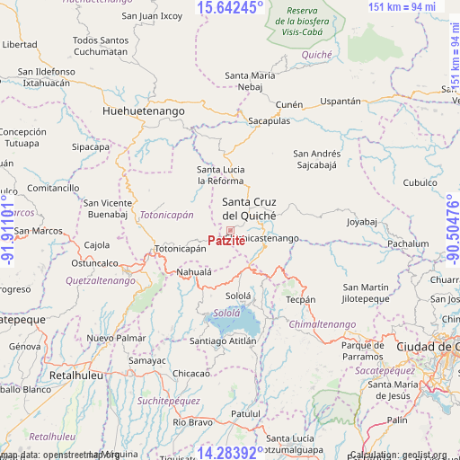
Patzité GPS coordinates[2]
14° 57' 51.336" North, 91° 12' 28.368" West
| Map corner | latitude | longitude |
|---|---|---|
| Upper-left | 15.64245°, | -91.91101° |
| Center: | 14.96426°, | -91.20788° |
| Lower-right: | 14.28392°, | -90.50476° |
| Map W x H: | 151.1×151.1 km | = 93.9×93.9mi |
| max Lat: | 17.06606° ⇑35.4% North |
| Patzité: | 14.96426° |
| min Lat: | ⇓64.6% South 13.9274° |
| min Long | Patzité | max Long |
| -92.19298° | -91.20788° | -88.59444° |
| W 40.7%⇐ | ⇒59.3% E |
Elevation
Elevation of Patzité is 2300 m = 7546 ft, and this is 1033 m = 3389 ft above average elevation for this country.
| Max E: |
3254 m = 10676 ft | 13.9% |
| Patzité | 2300 m 7546 ft | |
| Avg. | 1267 m = 4157 ft | |
Min E: |
1 m = 3 ft | 86.1% |
See also: Guatemala elevation on elevation.city.
Geographical zone
Patzité is located in North Torrid zone (between Equator and Tropic of Cancer). Distance of this Northern Tropic circle is 942 km =585.3 mi to North.| Distance of | km | miles | from Patzité |
|---|---|---|---|
| North Pole | 8343.2 | 5184.2 | to North |
| Arctic Circle | 5737.3 | 3565 | to North |
| Tropic Cancer | 942 | 585.3 | to North |
| Equator | 1663.9 | 1033.9 | to South |


Nearby cities:
15 places around Patzité: (largest is in red/bold)
• Chichicastenango
10.6 km =6.6 mi,  102°
102°
• Chiché
16.3 km =10.1 mi,  72°
72°
• Chinique
21.3 km =13.2 mi, 66°
• Concepción
21 km =13 mi,  162°
162°
• Momostenango
23.3 km =14.5 mi,  292°
292°
• Nahualá
17.9 km =11.1 mi,  221°
221°
• San Antonio Ilotenango
10.3 km =6.4 mi,  346°
346°
• San José Chacayá
21.5 km =13.4 mi,  182°
182°
• San Pédro Jocopilas
15.8 km =9.8 mi,  22°
22°
• Santa Cruz del Quiché
9.8 km =6.1 mi,  40°
40°
• Santa Lucia La Reforma
18.5 km =11.5 mi, 350°
• Santa Lucía Utatlán
22.4 km =13.9 mi,  196°
196°
• Santa María Chiquimula
14.9 km =9.3 mi,  299°
299°
• Sololá
21.5 km =13.4 mi,  172°
172°
• Totonicapán
17.5 km =10.9 mi,  250°
250°
Sources, notices
• [Note1] Compared only with cities in Guatemala existing in our database
• [Src1] Map data: © OpenStreetMap contributors (CC-BY-SA)
• [Src2] Other city data from geonames.org with taken over terms of usage.
• [Src3] Geographical zone / Annual Mean Temperature by Robert A. Rohde @ Wikipedia
