San Juan Ostuncalco geodata
San Juan Ostuncalco (Quetzaltenango) is a seat of a second-order administrative division; located in Guatemala in America/Guatemala (GMT-6) time zone. In our database, there are 325 cities with bigger population. Compared to other cities in Guatemala, 55.5% of cities are located further ↓South; 85% of cities are located further →East and 98.8% of cities have lower elevation than San Juan Ostuncalco. Note1


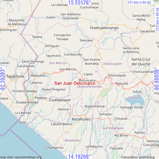
San Juan Ostuncalco GPS coordinates[2]
14° 52' 23.808" North, 91° 41' 22.92" West
| Map corner | latitude | longitude |
|---|---|---|
| Upper-left | 15.55176°, | -92.39283° |
| Center: | 14.87328°, | -91.6897° |
| Lower-right: | 14.19266°, | -90.98658° |
| Map W x H: | 151.1×151.1 km | = 93.9×93.9mi |
| max Lat: | 17.06606° ⇑44.5% North |
| San Juan Ostuncalco: | 14.87328° |
| min Lat: | ⇓55.5% South 13.9274° |
| min Long | San Juan Ostunc | max Long |
| -92.19298° | -91.6897° | -88.59444° |
| W 15%⇐ | ⇒85% E |
Elevation
Elevation of San Juan Ostuncalco is 2791 m = 9157 ft, and this is 1524 m = 5000 ft above average elevation for this country.
| Max E: |
3254 m = 10676 ft | 1.2% |
| San Juan Ostuncalco | 2791 m 9157 ft | |
| Avg. | 1267 m = 4157 ft | |
Min E: |
1 m = 3 ft | 98.8% |
See also: Guatemala elevation on elevation.city.
Geographical zone
San Juan Ostuncalco is located in North Torrid zone (between Equator and Tropic of Cancer). Distance of this Northern Tropic circle is 952.2 km =591.7 mi to North.| Distance of | km | miles | from San Juan Ostuncalco |
|---|---|---|---|
| North Pole | 8353.3 | 5190.5 | to North |
| Arctic Circle | 5747.4 | 3571.3 | to North |
| Tropic Cancer | 952.2 | 591.7 | to North |
| Equator | 1653.8 | 1027.6 | to South |


Nearby cities:
15 places around San Juan Ostuncalco: (largest is in red/bold)
• Cajolá
9.7 km =6 mi,  56°
56°
• Concepción Chiquirichapa
7.4 km =4.6 mi,  105°
105°
• Esquipulas Palo Gordo
16.5 km =10.3 mi,  297°
297°
• La Esperanza
13.8 km =8.6 mi,  90°
90°
• La Reforma
16.4 km =10.2 mi,  240°
240°
• Ostuncalco
7.4 km =4.6 mi, 93°
• Palestina de los Altos
6.7 km =4.2 mi,  356°
356°
• San Antonio Sacatepéquez
10.7 km =6.6 mi,  335°
335°
• San Cristóbal Cucho
10.5 km =6.5 mi,  289°
289°
• San Marcos
15.1 km =9.4 mi,  311°
311°
• San Martín Sacatepéquez
7.5 km =4.7 mi,  136°
136°
• San Mateo
10.8 km =6.7 mi,  99°
99°
• San Miguel Sigüilá
8.4 km =5.2 mi,  73°
73°
• San Pedro Sacatepéquez
13.1 km =8.1 mi,  323°
323°
• Sibilia
15.2 km =9.4 mi,  27°
27°
Sources, notices
• [Note1] Compared only with cities in Guatemala existing in our database
• [Src1] Map data: © OpenStreetMap contributors (CC-BY-SA)
• [Src2] Other city data from geonames.org with taken over terms of usage.
• [Src3] Geographical zone / Annual Mean Temperature by Robert A. Rohde @ Wikipedia
