San Pedro Sacatepéquez geodata
San Pedro Sacatepéquez (Guatemala) is a seat of a second-order administrative division; located in Guatemala in America/Guatemala (GMT-6) time zone. With population of 14,315 people, there are 86 cities with bigger population in this country. Compared to other cities in Guatemala, 61.4% of cities are located further ↑North; 62.5% of cities are located further ←West and 80.2% of cities have lower elevation than San Pedro Sacatepéquez. Note1


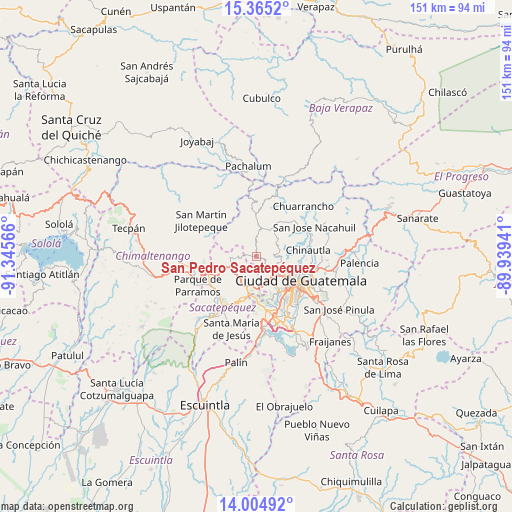
San Pedro Sacatepéquez GPS coordinates[2]
14° 41' 10.032" North, 90° 38' 33.108" West
| Map corner | latitude | longitude |
|---|---|---|
| Upper-left | 15.3652°, | -91.34566° |
| Center: | 14.68612°, | -90.64253° |
| Lower-right: | 14.00492°, | -89.93941° |
| Map W x H: | 151.2×151.3 km | = 94×94mi |
| max Lat: | 17.06606° ⇑61.4% North |
| San Pedro Sacatepéquez: | 14.68612° |
| min Lat: | ⇓38.6% South 13.9274° |
| min Long | San Pedro Sacat | max Long |
| -92.19298° | -90.64253° | -88.59444° |
| W 62.5%⇐ | ⇒37.5% E |
Elevation
Elevation of San Pedro Sacatepéquez is 2096 m = 6877 ft, and this is 829 m = 2720 ft above average elevation for this country.
| Max E: |
3254 m = 10676 ft | 19.8% |
| San Pedro Sacatepéquez | 2096 m 6877 ft | |
| Avg. | 1267 m = 4157 ft | |
Min E: |
1 m = 3 ft | 80.2% |
See also: Guatemala elevation on elevation.city.
Geographical zone
San Pedro Sacatepéquez is located in North Torrid zone (between Equator and Tropic of Cancer). Distance of this Northern Tropic circle is 973 km =604.6 mi to North.| Distance of | km | miles | from San Pedro Sacatepéquez |
|---|---|---|---|
| North Pole | 8374.1 | 5203.4 | to North |
| Arctic Circle | 5768.2 | 3584.2 | to North |
| Tropic Cancer | 973 | 604.6 | to North |
| Equator | 1632.9 | 1014.6 | to South |


Nearby cities:
15 places around San Pedro Sacatepéquez: (largest is in red/bold)
• Chinautla
15.5 km =9.6 mi,  83°
83°
• El Tejar
16.6 km =10.3 mi,  254°
254°
• Guatemala City
14.8 km =9.2 mi,  109°
109°
• Jocotenango
15.8 km =9.8 mi,  220°
220°
• Magdalena Milpas Altas
15.7 km =9.8 mi,  192°
192°
• Mixco
7.2 km =4.5 mi,  148°
148°
• Pastores
15.8 km =9.8 mi,  229°
229°
• San Bartolomé Milpas Altas
9.6 km =6 mi,  203°
203°
• San Juan Sacatepéquez
3.6 km =2.2 mi,  357°
357°
• San Lucas Sacatepéquez
8.5 km =5.3 mi, 190°
• San Raimundo
10.1 km =6.3 mi,  30°
30°
• Santa Lucía Milpas Altas
12.7 km =7.9 mi, 196°
• Santiago Sacatepéquez
6.8 km =4.2 mi,  212°
212°
• Santo Domingo Xenacoj
6.2 km =3.9 mi,  264°
264°
• Sumpango
10.8 km =6.7 mi, 245°
Sources, notices
• [Note1] Compared only with cities in Guatemala existing in our database
• [Src1] Map data: © OpenStreetMap contributors (CC-BY-SA)
• [Src2] Other city data from geonames.org with taken over terms of usage.
• [Src3] Geographical zone / Annual Mean Temperature by Robert A. Rohde @ Wikipedia
