Villa Nueva geodata
Villa Nueva (Guatemala) is a seat of a second-order administrative division; located in Guatemala in America/Guatemala (GMT-6) time zone. With population of 406,830 people, there are 2 cities with bigger population in this country. Compared to other cities in Guatemala, 79.9% of cities are located further ↑North; 64.3% of cities are located further ←West and 53.7% of cities have lower elevation than Villa Nueva. Note1


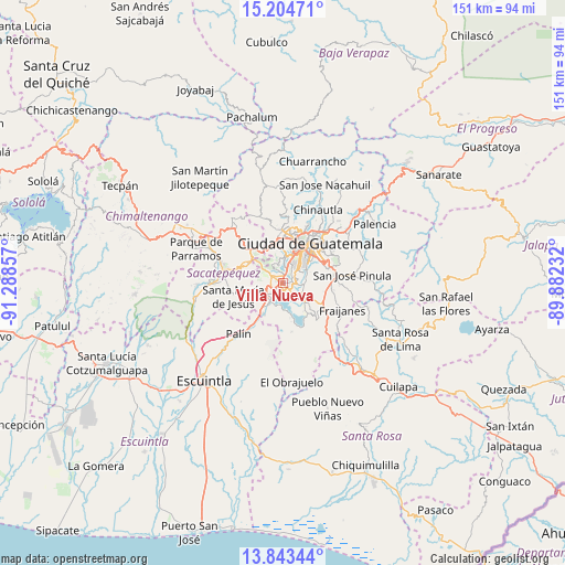
Villa Nueva GPS coordinates[2]
14° 31' 30.432" North, 90° 35' 7.584" West
| Map corner | latitude | longitude |
|---|---|---|
| Upper-left | 15.20471°, | -91.28857° |
| Center: | 14.52512°, | -90.58544° |
| Lower-right: | 13.84344°, | -89.88232° |
| Map W x H: | 151.4×151.4 km | = 94.1×94.1mi |
| max Lat: | 17.06606° ⇑79.9% North |
| Villa Nueva: | 14.52512° |
| min Lat: | ⇓20.1% South 13.9274° |
| min Long | Villa Nueva | max Long |
| -92.19298° | -90.58544° | -88.59444° |
| W 64.3%⇐ | ⇒35.7% E |
Elevation
Elevation of Villa Nueva is 1363 m = 4472 ft, and this is 96 m = 315 ft above average elevation for this country.
| Max E: |
3254 m = 10676 ft | 46.3% |
| Villa Nueva | 1363 m 4472 ft | |
| Avg. | 1267 m = 4157 ft | |
Min E: |
1 m = 3 ft | 53.7% |
See also: Villa Nueva elevation on elevation.city.
Geographical zone
Villa Nueva is located in North Torrid zone (between Equator and Tropic of Cancer). Distance of this Northern Tropic circle is 990.9 km =615.7 mi to North.| Distance of | km | miles | from Villa Nueva |
|---|---|---|---|
| North Pole | 8392 | 5214.5 | to North |
| Arctic Circle | 5786.1 | 3595.3 | to North |
| Tropic Cancer | 990.9 | 615.7 | to North |
| Equator | 1615 | 1003.5 | to South |


Nearby cities:
15 places around Villa Nueva: (largest is in red/bold)
• Amatitlán
7.5 km =4.7 mi,  225°
225°
• Antigua Guatemala
16.5 km =10.3 mi,  284°
284°
• Fraijanes
16.9 km =10.5 mi,  113°
113°
• Guatemala City
15 km =9.3 mi,  31°
31°
• Magdalena Milpas Altas
9.9 km =6.2 mi, 284°
• Mixco
12 km =7.5 mi,  348°
348°
• Petapa
3.6 km =2.2 mi,  135°
135°
• San Bartolomé Milpas Altas
13.5 km =8.4 mi,  312°
312°
• San Lucas Sacatepéquez
12.2 km =7.6 mi,  321°
321°
• San Vicente Pacaya
13.4 km =8.3 mi,  203°
203°
• Santa Catarina Pinula
10.6 km =6.6 mi,  61°
61°
• Santa Lucía Milpas Altas
11.3 km =7 mi,  300°
300°
• Santa María de Jesús
13.9 km =8.6 mi,  255°
255°
• Santiago Sacatepéquez
15.7 km =9.8 mi, 321°
• Villa Canales
7.2 km =4.5 mi,  130°
130°
Sources, notices
• [Note1] Compared only with cities in Guatemala existing in our database
• [Src1] Map data: © OpenStreetMap contributors (CC-BY-SA)
• [Src2] Other city data from geonames.org with taken over terms of usage.
• [Src3] Geographical zone / Annual Mean Temperature by Robert A. Rohde @ Wikipedia
