Amatitlán geodata
Amatitlán (Guatemala) is a seat of a second-order administrative division; located in Guatemala in America/Guatemala (GMT-6) time zone. With population of 71,836 people, there are 12 cities with bigger population in this country. Compared to other cities in Guatemala, 85% of cities are located further ↑North; 63.1% of cities are located further ←West and 51.9% of cities have higher elevation than Amatitlán. Note1


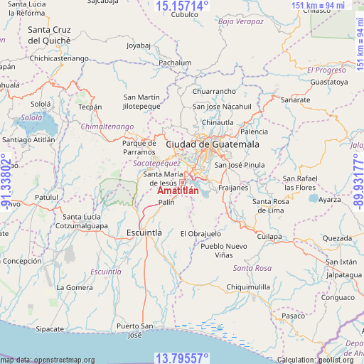
Amatitlán GPS coordinates[2]
14° 28' 38.64" North, 90° 38' 5.604" West
| Map corner | latitude | longitude |
|---|---|---|
| Upper-left | 15.15714°, | -91.33802° |
| Center: | 14.4774°, | -90.63489° |
| Lower-right: | 13.79557°, | -89.93177° |
| Map W x H: | 151.4×151.4 km | = 94.1×94.1mi |
| max Lat: | 17.06606° ⇑85% North |
| Amatitlán: | 14.4774° |
| min Lat: | ⇓15% South 13.9274° |
| min Long | Amatitlán | max Long |
| -92.19298° | -90.63489° | -88.59444° |
| W 63.1%⇐ | ⇒36.9% E |
Elevation
Elevation of Amatitlán is 1219 m = 3999 ft, and this is 48 m = 157 ft below average elevation for this country.
| Max E: |
3254 m = 10676 ft | 51.9% |
| Avg. | 1267 m = 4157 ft | |
| Amatitlán | 1219 m = 3999 ft | |
Min E: |
1 m = 3 ft | 48.1% |
See also: Amatitlán elevation on elevation.city.
Geographical zone
Amatitlán is located in North Torrid zone (between Equator and Tropic of Cancer). Distance of this Northern Tropic circle is 996.2 km =619 mi to North.| Distance of | km | miles | from Amatitlán |
|---|---|---|---|
| North Pole | 8397.3 | 5217.8 | to North |
| Arctic Circle | 5791.4 | 3598.6 | to North |
| Tropic Cancer | 996.2 | 619 | to North |
| Equator | 1609.7 | 1000.2 | to South |


Nearby cities:
15 places around Amatitlán: (largest is in red/bold)
• Antigua Guatemala
14.2 km =8.8 mi,  310°
310°
• Ciudad Vieja
14.7 km =9.1 mi,  290°
290°
• Jocotenango
15.8 km =9.8 mi,  315°
315°
• Magdalena Milpas Altas
8.9 km =5.5 mi,  331°
331°
• Mixco
17.3 km =10.7 mi,  9°
9°
• Palín
10.6 km =6.6 mi,  218°
218°
• Petapa
8.3 km =5.2 mi,  70°
70°
• San Antonio Aguas Calientes
17.5 km =10.9 mi,  296°
296°
• San Bartolomé Milpas Altas
15.1 km =9.4 mi,  342°
342°
• San Lucas Sacatepéquez
15 km =9.3 mi,  350°
350°
• San Vicente Pacaya
7 km =4.3 mi,  181°
181°
• Santa Lucía Milpas Altas
11.9 km =7.4 mi, 337°
• Santa María de Jesús
8.3 km =5.2 mi,  283°
283°
• Villa Canales
10.9 km =6.8 mi,  86°
86°
• Villa Nueva
7.5 km =4.7 mi,  45°
45°
Sources, notices
• [Note1] Compared only with cities in Guatemala existing in our database
• [Src1] Map data: © OpenStreetMap contributors (CC-BY-SA)
• [Src2] Other city data from geonames.org with taken over terms of usage.
• [Src3] Geographical zone / Annual Mean Temperature by Robert A. Rohde @ Wikipedia
