Mixco geodata
Mixco (Guatemala) is a seat of a second-order administrative division; located in Guatemala in America/Guatemala (GMT-6) time zone. With population of 473,080 people, there is 1 city with bigger population in this country. Compared to other cities in Guatemala, 68.1% of cities are located further ↑North; 63.7% of cities are located further ←West and 65.8% of cities have lower elevation than Mixco. Note1


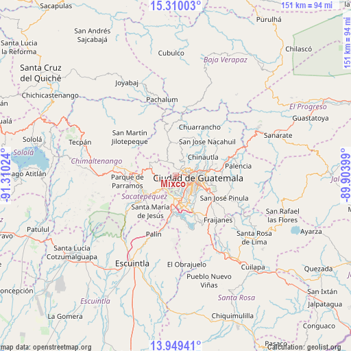
Mixco GPS coordinates[2]
14° 37' 50.772" North, 90° 36' 25.596" West
| Map corner | latitude | longitude |
|---|---|---|
| Upper-left | 15.31003°, | -91.31024° |
| Center: | 14.63077°, | -90.60711° |
| Lower-right: | 13.94941°, | -89.90399° |
| Map W x H: | 151.3×151.3 km | = 94×94mi |
| max Lat: | 17.06606° ⇑68.1% North |
| Mixco: | 14.63077° |
| min Lat: | ⇓31.9% South 13.9274° |
| min Long | Mixco | max Long |
| -92.19298° | -90.60711° | -88.59444° |
| W 63.7%⇐ | ⇒36.3% E |
Elevation
Elevation of Mixco is 1692 m = 5551 ft, and this is 425 m = 1394 ft above average elevation for this country.
| Max E: |
3254 m = 10676 ft | 34.2% |
| Mixco | 1692 m 5551 ft | |
| Avg. | 1267 m = 4157 ft | |
Min E: |
1 m = 3 ft | 65.8% |
See also: Mixco elevation on elevation.city.
Geographical zone
Mixco is located in North Torrid zone (between Equator and Tropic of Cancer). Distance of this Northern Tropic circle is 979.1 km =608.4 mi to North.| Distance of | km | miles | from Mixco |
|---|---|---|---|
| North Pole | 8380.3 | 5207.3 | to North |
| Arctic Circle | 5774.4 | 3588 | to North |
| Tropic Cancer | 979.1 | 608.4 | to North |
| Equator | 1626.8 | 1010.8 | to South |


Nearby cities:
15 places around Mixco: (largest is in red/bold)
• Chinautla
14.1 km =8.8 mi,  55°
55°
• Guatemala City
10.2 km =6.3 mi,  83°
83°
• Magdalena Milpas Altas
11.7 km =7.3 mi,  218°
218°
• Petapa
15.1 km =9.4 mi,  161°
161°
• San Bartolomé Milpas Altas
8.1 km =5 mi,  250°
250°
• San Juan Sacatepéquez
10.6 km =6.6 mi,  337°
337°
• San Lucas Sacatepéquez
5.8 km =3.6 mi, 247°
• San Pedro Sacatepéquez
7.2 km =4.5 mi,  328°
328°
• San Raimundo
14.9 km =9.3 mi,  5°
5°
• Santa Catarina Pinula
13.4 km =8.3 mi,  120°
120°
• Santa Lucía Milpas Altas
9.6 km =6 mi,  231°
231°
• Santiago Sacatepéquez
7.5 km =4.7 mi,  273°
273°
• Santo Domingo Xenacoj
11.4 km =7.1 mi,  298°
298°
• Sumpango
13.8 km =8.6 mi,  277°
277°
• Villa Nueva
12 km =7.5 mi,  168°
168°
Sources, notices
• [Note1] Compared only with cities in Guatemala existing in our database
• [Src1] Map data: © OpenStreetMap contributors (CC-BY-SA)
• [Src2] Other city data from geonames.org with taken over terms of usage.
• [Src3] Geographical zone / Annual Mean Temperature by Robert A. Rohde @ Wikipedia
