San José Ojetenam geodata
San José Ojetenam (San Marcos) is a seat of a second-order administrative division; located in Guatemala in America/Guatemala (GMT-6) time zone. In our database, there are 325 cities with bigger population. Compared to other cities in Guatemala, 76.4% of cities are located further ↓South; 96.8% of cities are located further →East and 99.4% of cities have lower elevation than San José Ojetenam. Note1


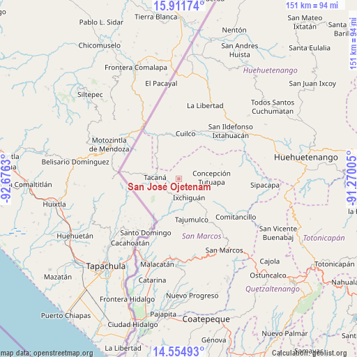
San José Ojetenam GPS coordinates[2]
15° 14' 3.948" North, 91° 58' 23.412" West
| Map corner | latitude | longitude |
|---|---|---|
| Upper-left | 15.91174°, | -92.6763° |
| Center: | 15.23443°, | -91.97317° |
| Lower-right: | 14.55493°, | -91.27005° |
| Map W x H: | 150.9×150.9 km | = 93.8×93.8mi |
| max Lat: | 17.06606° ⇑23.6% North |
| San José Ojetenam: | 15.23443° |
| min Lat: | ⇓76.4% South 13.9274° |
| min Long | San José Ojete | max Long |
| -92.19298° | -91.97317° | -88.59444° |
| W 3.2%⇐ | ⇒96.8% E |
Elevation
Elevation of San José Ojetenam is 3056 m = 10026 ft, and this is 1789 m = 5869 ft above average elevation for this country.
| Max E: |
3254 m = 10676 ft | 0.59999999999999% |
| San José Ojetenam | 3056 m 10026 ft | |
| Avg. | 1267 m = 4157 ft | |
Min E: |
1 m = 3 ft | 99.4% |
See also: Guatemala elevation on elevation.city.
Geographical zone
San José Ojetenam is located in North Torrid zone (between Equator and Tropic of Cancer). Distance of this Northern Tropic circle is 912 km =566.7 mi to North.| Distance of | km | miles | from San José Ojetenam |
|---|---|---|---|
| North Pole | 8313.2 | 5165.6 | to North |
| Arctic Circle | 5707.3 | 3546.4 | to North |
| Tropic Cancer | 912 | 566.7 | to North |
| Equator | 1693.9 | 1052.5 | to South |


Nearby cities:
15 places around San José Ojetenam: (largest is in red/bold)
• Comitancillo
28.9 km =18 mi,  123°
123°
• Concepción Tutuapa
13.8 km =8.6 mi,  87°
87°
• Cuilco
19.4 km =12.1 mi,  8°
8°
• Ixchiguán
9 km =5.6 mi,  150°
150°
• Ixtahuacán
29.8 km =18.5 mi,  47°
47°
• La Libertad
33 km =20.5 mi,  19°
19°
• San Gaspar Ixchil
31.6 km =19.6 mi,  57°
57°
• San José Ojetenán
2.1 km =1.3 mi,  160°
160°
• San Miguel Ixtahuacán
24.5 km =15.2 mi,  80°
80°
• San Pablo
33.7 km =20.9 mi,  185°
185°
• Sibinal
12.4 km =7.7 mi,  220°
220°
• Tacaná
10.1 km =6.3 mi,  273°
273°
• Tajumulco
17.7 km =11 mi, 161°
• Tectitán
12.3 km =7.6 mi,  310°
310°
• Tejutla
21.8 km =13.5 mi, 124°
Sources, notices
• [Note1] Compared only with cities in Guatemala existing in our database
• [Src1] Map data: © OpenStreetMap contributors (CC-BY-SA)
• [Src2] Other city data from geonames.org with taken over terms of usage.
• [Src3] Geographical zone / Annual Mean Temperature by Robert A. Rohde @ Wikipedia
