San José Ojetenán geodata
San José Ojetenán (San Marcos) is a populated place; located in Guatemala in America/Guatemala (GMT-6) time zone. With population of 1,269 people, there are 306 cities with bigger population in this country. Compared to other cities in Guatemala, 76.1% of cities are located further ↓South; 96.5% of cities are located further →East and 100% of cities have lower elevation than San José Ojetenán. Note1


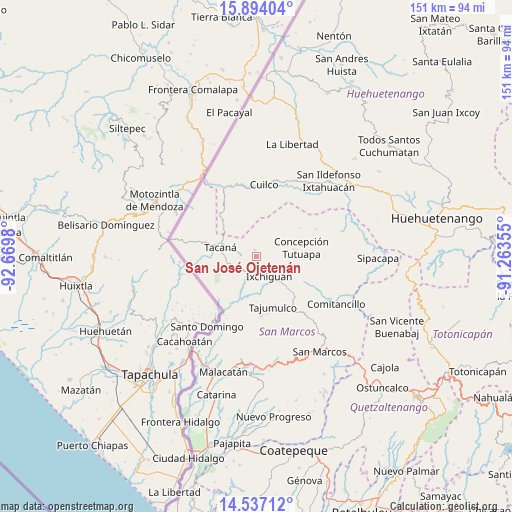
San José Ojetenán GPS coordinates[2]
15° 13' 0.012" North, 91° 58' 0.012" West
| Map corner | latitude | longitude |
|---|---|---|
| Upper-left | 15.89404°, | -92.6698° |
| Center: | 15.21667°, | -91.96667° |
| Lower-right: | 14.53712°, | -91.26355° |
| Map W x H: | 150.9×150.9 km | = 93.8×93.8mi |
| max Lat: | 17.06606° ⇑23.9% North |
| San José Ojetenán: | 15.21667° |
| min Lat: | ⇓76.1% South 13.9274° |
| min Long | San José Ojete | max Long |
| -92.19298° | -91.96667° | -88.59444° |
| W 3.5%⇐ | ⇒96.5% E |
Elevation
Elevation of San José Ojetenán is 3254 m = 10676 ft, and this is 1987 m = 6519 ft above average elevation for this country.
| Max E: |
3254 m = 10676 ft | 0% |
| San José Ojetenán | 3254 m 10676 ft | |
| Avg. | 1267 m = 4157 ft | |
Min E: |
1 m = 3 ft | 100% |
See also: Guatemala elevation on elevation.city.
Geographical zone
San José Ojetenán is located in North Torrid zone (between Equator and Tropic of Cancer). Distance of this Northern Tropic circle is 914 km =567.9 mi to North.| Distance of | km | miles | from San José Ojetenán |
|---|---|---|---|
| North Pole | 8315.1 | 5166.8 | to North |
| Arctic Circle | 5709.2 | 3547.5 | to North |
| Tropic Cancer | 914 | 567.9 | to North |
| Equator | 1691.9 | 1051.3 | to South |


Nearby cities:
15 places around San José Ojetenán: (largest is in red/bold)
• Comitancillo
27.2 km =16.9 mi,  121°
121°
• Concepción Tutuapa
13.3 km =8.3 mi,  79°
79°
• Cuilco
21.3 km =13.2 mi,  5°
5°
• Ixchiguán
6.9 km =4.3 mi,  148°
148°
• Ixtahuacán
30.7 km =19.1 mi,  43°
43°
• San Gaspar Ixchil
32.1 km =19.9 mi,  53°
53°
• San José Ojetenam
2.1 km =1.3 mi,  340°
340°
• San Lorenzo
32.3 km =20.1 mi,  129°
129°
• San Miguel Ixtahuacán
24.3 km =15.1 mi, 75°
• San Pablo
31.8 km =19.8 mi,  187°
187°
• Sibinal
11.6 km =7.2 mi,  229°
229°
• Tacaná
11.1 km =6.9 mi,  283°
283°
• Tajumulco
15.6 km =9.7 mi,  162°
162°
• Tectitán
14.2 km =8.8 mi,  314°
314°
• Tejutla
20.1 km =12.5 mi, 121°
Sources, notices
• [Note1] Compared only with cities in Guatemala existing in our database
• [Src1] Map data: © OpenStreetMap contributors (CC-BY-SA)
• [Src2] Other city data from geonames.org with taken over terms of usage.
• [Src3] Geographical zone / Annual Mean Temperature by Robert A. Rohde @ Wikipedia
