San Miguel Ixtahuacán geodata
San Miguel Ixtahuacán (San Marcos) is a seat of a second-order administrative division; located in Guatemala in America/Guatemala (GMT-6) time zone. With population of 3,662 people, there are 229 cities with bigger population in this country. Compared to other cities in Guatemala, 78.2% of cities are located further ↓South; 88.2% of cities are located further →East and 77.6% of cities have lower elevation than San Miguel Ixtahuacán. Note1


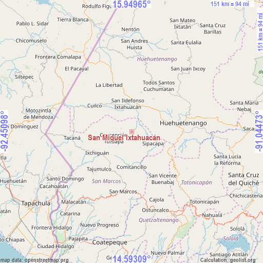
San Miguel Ixtahuacán GPS coordinates[2]
15° 16' 20.892" North, 91° 44' 52.26" West
| Map corner | latitude | longitude |
|---|---|---|
| Upper-left | 15.94965°, | -92.45098° |
| Center: | 15.27247°, | -91.74785° |
| Lower-right: | 14.59309°, | -91.04473° |
| Map W x H: | 150.8×150.8 km | = 93.7×93.7mi |
| max Lat: | 17.06606° ⇑21.8% North |
| San Miguel Ixtahuacán: | 15.27247° |
| min Lat: | ⇓78.2% South 13.9274° |
| min Long | San Miguel Ixta | max Long |
| -92.19298° | -91.74785° | -88.59444° |
| W 11.8%⇐ | ⇒88.2% E |
Elevation
Elevation of San Miguel Ixtahuacán is 2057 m = 6749 ft, and this is 790 m = 2592 ft above average elevation for this country.
| Max E: |
3254 m = 10676 ft | 22.4% |
| San Miguel Ixtahuacán | 2057 m 6749 ft | |
| Avg. | 1267 m = 4157 ft | |
Min E: |
1 m = 3 ft | 77.6% |
See also: Guatemala elevation on elevation.city.
Geographical zone
San Miguel Ixtahuacán is located in North Torrid zone (between Equator and Tropic of Cancer). Distance of this Northern Tropic circle is 907.8 km =564.1 mi to North.| Distance of | km | miles | from San Miguel Ixtahuacán |
|---|---|---|---|
| North Pole | 8308.9 | 5162.9 | to North |
| Arctic Circle | 5703 | 3543.7 | to North |
| Tropic Cancer | 907.8 | 564.1 | to North |
| Equator | 1698.1 | 1055.2 | to South |


Nearby cities:
15 places around San Miguel Ixtahuacán: (largest is in red/bold)
• Cabricán
24.4 km =15.2 mi,  154°
154°
• Colotenango
15.3 km =9.5 mi,  14°
14°
• Comitancillo
20.4 km =12.7 mi,  180°
180°
• Concepción Tutuapa
11 km =6.8 mi,  250°
250°
• Ixchiguán
23.2 km =14.4 mi,  238°
238°
• Ixtahuacán
16.2 km =10.1 mi,  351°
351°
• San Gaspar Ixchil
13.1 km =8.1 mi, 10°
• San José Ojetenán
24.3 km =15.1 mi,  255°
255°
• San Juan Atitán
21.9 km =13.6 mi,  37°
37°
• San Rafael Petzal
17.2 km =10.7 mi,  31°
31°
• San Sebastián Huehuetenango
19.1 km =11.9 mi,  47°
47°
• Santa Bárbara
13.3 km =8.3 mi,  68°
68°
• Santiago Chimaltenango
23.4 km =14.5 mi, 13°
• Sipacapa
13.9 km =8.6 mi,  118°
118°
• Tejutla
17.8 km =11.1 mi,  200°
200°
Sources, notices
• [Note1] Compared only with cities in Guatemala existing in our database
• [Src1] Map data: © OpenStreetMap contributors (CC-BY-SA)
• [Src2] Other city data from geonames.org with taken over terms of usage.
• [Src3] Geographical zone / Annual Mean Temperature by Robert A. Rohde @ Wikipedia
