Comitancillo geodata
Comitancillo (San Marcos) is a seat of a second-order administrative division; located in Guatemala in America/Guatemala (GMT-6) time zone. With population of 19,669 people, there are 56 cities with bigger population in this country. Compared to other cities in Guatemala, 72% of cities are located further ↓South; 88.5% of cities are located further →East and 85.5% of cities have lower elevation than Comitancillo. Note1


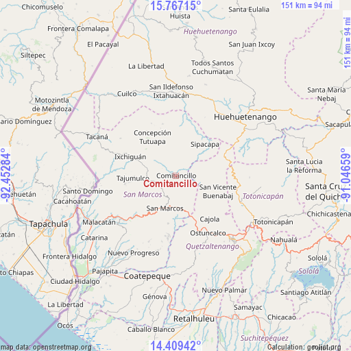
Comitancillo GPS coordinates[2]
15° 5' 21.732" North, 91° 44' 58.956" West
| Map corner | latitude | longitude |
|---|---|---|
| Upper-left | 15.76715°, | -92.45284° |
| Center: | 15.08937°, | -91.74971° |
| Lower-right: | 14.40942°, | -91.04659° |
| Map W x H: | 151×151 km | = 93.8×93.8mi |
| max Lat: | 17.06606° ⇑28% North |
| Comitancillo: | 15.08937° |
| min Lat: | ⇓72% South 13.9274° |
| min Long | Comitancillo | max Long |
| -92.19298° | -91.74971° | -88.59444° |
| W 11.5%⇐ | ⇒88.5% E |
Elevation
Elevation of Comitancillo is 2271 m = 7451 ft, and this is 1004 m = 3294 ft above average elevation for this country.
| Max E: |
3254 m = 10676 ft | 14.5% |
| Comitancillo | 2271 m 7451 ft | |
| Avg. | 1267 m = 4157 ft | |
Min E: |
1 m = 3 ft | 85.5% |
See also: Guatemala elevation on elevation.city.
Geographical zone
Comitancillo is located in North Torrid zone (between Equator and Tropic of Cancer). Distance of this Northern Tropic circle is 928.1 km =576.7 mi to North.| Distance of | km | miles | from Comitancillo |
|---|---|---|---|
| North Pole | 8329.3 | 5175.6 | to North |
| Arctic Circle | 5723.4 | 3556.4 | to North |
| Tropic Cancer | 928.1 | 576.7 | to North |
| Equator | 1677.8 | 1042.5 | to South |


Nearby cities:
15 places around Comitancillo: (largest is in red/bold)
• Cabricán
11 km =6.8 mi,  98°
98°
• Concepción Tutuapa
19.5 km =12.1 mi,  328°
328°
• Esquipulas Palo Gordo
18.4 km =11.4 mi,  206°
206°
• Huitán
12.7 km =7.9 mi,  110°
110°
• Palestina de los Altos
18.3 km =11.4 mi,  160°
160°
• Río Blanco
9 km =5.6 mi,  129°
129°
• San Antonio Sacatepéquez
14.5 km =9 mi,  172°
172°
• San Lorenzo
6.7 km =4.2 mi, 166°
• San Marcos
14.8 km =9.2 mi,  198°
198°
• San Miguel Ixtahuacán
20.4 km =12.7 mi,  0°
0°
• San Pedro Sacatepéquez
13.5 km =8.4 mi,  185°
185°
• Sibilia
17.2 km =10.7 mi, 128°
• Sipacapa
18.5 km =11.5 mi,  42°
42°
• Tajumulco
18.5 km =11.5 mi,  267°
267°
• Tejutla
7.1 km =4.4 mi,  301°
301°
Sources, notices
• [Note1] Compared only with cities in Guatemala existing in our database
• [Src1] Map data: © OpenStreetMap contributors (CC-BY-SA)
• [Src2] Other city data from geonames.org with taken over terms of usage.
• [Src3] Geographical zone / Annual Mean Temperature by Robert A. Rohde @ Wikipedia
