Tejutla geodata
Tejutla (San Marcos) is a seat of a second-order administrative division; located in Guatemala in America/Guatemala (GMT-6) time zone. With population of 2,653 people, there are 255 cities with bigger population in this country. Compared to other cities in Guatemala, 73.7% of cities are located further ↓South; 91.2% of cities are located further →East and 91.4% of cities have lower elevation than Tejutla. Note1


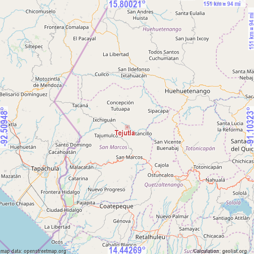
Tejutla GPS coordinates[2]
15° 7' 21.144" North, 91° 48' 22.86" West
| Map corner | latitude | longitude |
|---|---|---|
| Upper-left | 15.80021°, | -92.50948° |
| Center: | 15.12254°, | -91.80635° |
| Lower-right: | 14.44269°, | -91.10323° |
| Map W x H: | 150.9×150.9 km | = 93.8×93.8mi |
| max Lat: | 17.06606° ⇑26.3% North |
| Tejutla: | 15.12254° |
| min Lat: | ⇓73.7% South 13.9274° |
| min Long | Tejutla | max Long |
| -92.19298° | -91.80635° | -88.59444° |
| W 8.8%⇐ | ⇒91.2% E |
Elevation
Elevation of Tejutla is 2481 m = 8140 ft, and this is 1214 m = 3983 ft above average elevation for this country.
| Max E: |
3254 m = 10676 ft | 8.6% |
| Tejutla | 2481 m 8140 ft | |
| Avg. | 1267 m = 4157 ft | |
Min E: |
1 m = 3 ft | 91.4% |
See also: Guatemala elevation on elevation.city.
Geographical zone
Tejutla is located in North Torrid zone (between Equator and Tropic of Cancer). Distance of this Northern Tropic circle is 924.5 km =574.5 mi to North.| Distance of | km | miles | from Tejutla |
|---|---|---|---|
| North Pole | 8325.6 | 5173.3 | to North |
| Arctic Circle | 5719.7 | 3554.1 | to North |
| Tropic Cancer | 924.5 | 574.5 | to North |
| Equator | 1681.5 | 1044.8 | to South |


Nearby cities:
15 places around Tejutla: (largest is in red/bold)
• Cabricán
17.8 km =11.1 mi,  107°
107°
• Comitancillo
7.1 km =4.4 mi,  121°
121°
• Concepción Tutuapa
13.6 km =8.5 mi,  342°
342°
• Esquipulas Palo Gordo
20.3 km =12.6 mi,  185°
185°
• Huitán
19.7 km =12.2 mi, 114°
• Ixchiguán
14.3 km =8.9 mi,  288°
288°
• Río Blanco
16.1 km =10 mi,  125°
125°
• San Antonio Sacatepéquez
19.7 km =12.2 mi,  155°
155°
• San José Ojetenán
20.1 km =12.5 mi,  301°
301°
• San Lorenzo
12.7 km =7.9 mi,  143°
143°
• San Marcos
17.7 km =11 mi,  175°
175°
• San Miguel Ixtahuacán
17.8 km =11.1 mi,  20°
20°
• San Pedro Sacatepéquez
17.8 km =11.1 mi, 164°
• Sipacapa
21 km =13 mi,  61°
61°
• Tajumulco
13.2 km =8.2 mi,  250°
250°
Sources, notices
• [Note1] Compared only with cities in Guatemala existing in our database
• [Src1] Map data: © OpenStreetMap contributors (CC-BY-SA)
• [Src2] Other city data from geonames.org with taken over terms of usage.
• [Src3] Geographical zone / Annual Mean Temperature by Robert A. Rohde @ Wikipedia
