Tajumulco geodata
Tajumulco (San Marcos) is a seat of a second-order administrative division; located in Guatemala in America/Guatemala (GMT-6) time zone. With population of 4,329 people, there are 215 cities with bigger population in this country. Compared to other cities in Guatemala, 71.1% of cities are located further ↓South; 95.3% of cities are located further →East and 78.2% of cities have lower elevation than Tajumulco. Note1


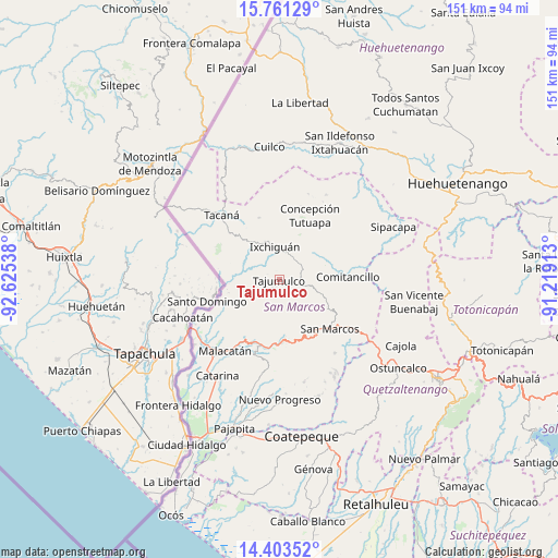
Tajumulco GPS coordinates[2]
15° 5' 0.564" North, 91° 55' 20.1" West
| Map corner | latitude | longitude |
|---|---|---|
| Upper-left | 15.76129°, | -92.62538° |
| Center: | 15.08349°, | -91.92225° |
| Lower-right: | 14.40352°, | -91.21913° |
| Map W x H: | 151×151 km | = 93.8×93.8mi |
| max Lat: | 17.06606° ⇑28.9% North |
| Tajumulco: | 15.08349° |
| min Lat: | ⇓71.1% South 13.9274° |
| min Long | Tajumulco | max Long |
| -92.19298° | -91.92225° | -88.59444° |
| W 4.7%⇐ | ⇒95.3% E |
Elevation
Elevation of Tajumulco is 2066 m = 6778 ft, and this is 799 m = 2621 ft above average elevation for this country.
| Max E: |
3254 m = 10676 ft | 21.8% |
| Tajumulco | 2066 m 6778 ft | |
| Avg. | 1267 m = 4157 ft | |
Min E: |
1 m = 3 ft | 78.2% |
See also: Guatemala elevation on elevation.city.
Geographical zone
Tajumulco is located in North Torrid zone (between Equator and Tropic of Cancer). Distance of this Northern Tropic circle is 928.8 km =577.1 mi to North.| Distance of | km | miles | from Tajumulco |
|---|---|---|---|
| North Pole | 8329.9 | 5176 | to North |
| Arctic Circle | 5724 | 3556.7 | to North |
| Tropic Cancer | 928.8 | 577.1 | to North |
| Equator | 1677.1 | 1042.1 | to South |


Nearby cities:
15 places around Tajumulco: (largest is in red/bold)
• Comitancillo
18.5 km =11.5 mi,  87°
87°
• Concepción Tutuapa
19.2 km =11.9 mi,  25°
25°
• El Rodeo
19.7 km =12.2 mi,  197°
197°
• Esquipulas Palo Gordo
18.9 km =11.7 mi,  146°
146°
• Ixchiguán
9 km =5.6 mi,  352°
352°
• San José Ojetenam
17.7 km =11 mi,  341°
341°
• San José Ojetenán
15.6 km =9.7 mi, 342°
• San Lorenzo
20.9 km =13 mi,  106°
106°
• San Marcos
19.1 km =11.9 mi,  134°
134°
• San Pablo
18.9 km =11.7 mi,  207°
207°
• San Pedro Sacatepéquez
21.5 km =13.4 mi, 126°
• San Rafael Pie de la Cuesta
17 km =10.6 mi,  176°
176°
• Sibinal
15.5 km =9.6 mi,  298°
298°
• Tacaná
23.4 km =14.5 mi,  318°
318°
• Tejutla
13.2 km =8.2 mi,  70°
70°
Sources, notices
• [Note1] Compared only with cities in Guatemala existing in our database
• [Src1] Map data: © OpenStreetMap contributors (CC-BY-SA)
• [Src2] Other city data from geonames.org with taken over terms of usage.
• [Src3] Geographical zone / Annual Mean Temperature by Robert A. Rohde @ Wikipedia
