Río Hondo geodata
Río Hondo (Zacapa) is a seat of a second-order administrative division; located in Guatemala in America/Guatemala (GMT-6) time zone. With population of 5,997 people, there are 188 cities with bigger population in this country. Compared to other cities in Guatemala, 70.5% of cities are located further ↓South; 92.9% of cities are located further ←West and 72.9% of cities have higher elevation than Río Hondo. Note1


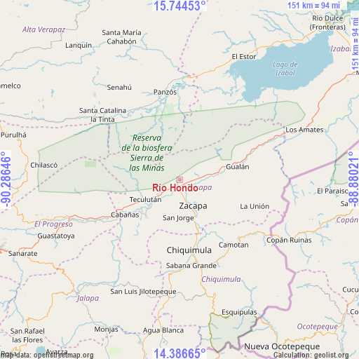
Río Hondo GPS coordinates[2]
15° 4' 0.012" North, 89° 34' 59.988" West
| Map corner | latitude | longitude |
|---|---|---|
| Upper-left | 15.74453°, | -90.28646° |
| Center: | 15.06667°, | -89.58333° |
| Lower-right: | 14.38665°, | -88.88021° |
| Map W x H: | 151×151 km | = 93.8×93.8mi |
| max Lat: | 17.06606° ⇑29.5% North |
| Río Hondo: | 15.06667° |
| min Lat: | ⇓70.5% South 13.9274° |
| min Long | Río Hondo | max Long |
| -92.19298° | -89.58333° | -88.59444° |
| W 92.9%⇐ | ⇒7.1% E |
Elevation
Elevation of Río Hondo is 528 m = 1732 ft, and this is 739 m = 2425 ft below average elevation for this country.
| Max E: |
3254 m = 10676 ft | 72.9% |
| Avg. | 1267 m = 4157 ft | |
| Río Hondo | 528 m = 1732 ft | |
Min E: |
1 m = 3 ft | 27.1% |
See also: Guatemala elevation on elevation.city.
Geographical zone
Río Hondo is located in North Torrid zone (between Equator and Tropic of Cancer). Distance of this Northern Tropic circle is 930.7 km =578.3 mi to North.| Distance of | km | miles | from Río Hondo |
|---|---|---|---|
| North Pole | 8331.8 | 5177.1 | to North |
| Arctic Circle | 5725.9 | 3557.9 | to North |
| Tropic Cancer | 930.7 | 578.3 | to North |
| Equator | 1675.3 | 1041 | to South |


Nearby cities:
15 places around Río Hondo: (largest is in red/bold)
• Cabañas
27.6 km =17.1 mi,  237°
237°
• Camotán
35.6 km =22.1 mi,  140°
140°
• Chiquimula
29.9 km =18.6 mi,  172°
172°
• El Jícaro
37.9 km =23.5 mi, 243°
• Estanzuela
7.6 km =4.7 mi, 166°
• Gualán
25 km =15.5 mi,  76°
76°
• Huité
20.6 km =12.8 mi,  224°
224°
• Jocotán
34.3 km =21.3 mi, 142°
• La Unión
33.4 km =20.8 mi,  109°
109°
• San Cristóbal Acasaguastlán
36.3 km =22.6 mi, 242°
• San Jorge
14.8 km =9.2 mi,  180°
180°
• San Juan Ermita
37.4 km =23.2 mi,  153°
153°
• Teculután
17.1 km =10.6 mi, 237°
• Usumatlán
25.1 km =15.6 mi, 238°
• Zacapa
11.9 km =7.4 mi, 151°
Sources, notices
• [Note1] Compared only with cities in Guatemala existing in our database
• [Src1] Map data: © OpenStreetMap contributors (CC-BY-SA)
• [Src2] Other city data from geonames.org with taken over terms of usage.
• [Src3] Geographical zone / Annual Mean Temperature by Robert A. Rohde @ Wikipedia
