La Unión geodata
La Unión (Zacapa) is a seat of a second-order administrative division; located in Guatemala in America/Guatemala (GMT-6) time zone. With population of 3,682 people, there are 228 cities with bigger population in this country. Compared to other cities in Guatemala, 64.9% of cities are located further ↓South; 98.5% of cities are located further ←West and 57.8% of cities have higher elevation than La Unión. Note1


La Unión GPS coordinates[2]
14° 57' 59.616" North, 89° 17' 24.828" West
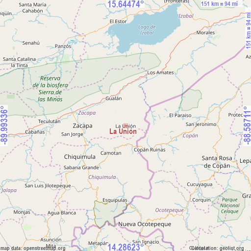
| Map corner | latitude | longitude |
|---|---|---|
| Upper-left | 15.64474°, | -89.99336° |
| Center: | 14.96656°, | -89.29023° |
| Lower-right: | 14.28623°, | -88.58711° |
| Map W x H: | 151.1×151.1 km | = 93.9×93.9mi |
| max Lat: | 17.06606° ⇑35.1% North |
| La Unión: | 14.96656° |
| min Lat: | ⇓64.9% South 13.9274° |
| min Long | La Unión | max Long |
| -92.19298° | -89.29023° | -88.59444° |
| W 98.5%⇐ | ⇒1.5% E |
Elevation
Elevation of La Unión is 994 m = 3261 ft, and this is 273 m = 896 ft below average elevation for this country.
| Max E: |
3254 m = 10676 ft | 57.8% |
| Avg. | 1267 m = 4157 ft | |
| La Unión | 994 m = 3261 ft | |
Min E: |
1 m = 3 ft | 42.2% |
See also: Guatemala elevation on elevation.city.
Geographical zone
La Unión is located in North Torrid zone (between Equator and Tropic of Cancer). Distance of this Northern Tropic circle is 941.8 km =585.2 mi to North.| Distance of | km | miles | from La Unión |
|---|---|---|---|
| North Pole | 8342.9 | 5184 | to North |
| Arctic Circle | 5737 | 3564.8 | to North |
| Tropic Cancer | 941.8 | 585.2 | to North |
| Equator | 1664.1 | 1034 | to South |


Nearby cities:
15 places around La Unión: (largest is in red/bold)
• Camotán
18.5 km =11.5 mi,  208°
208°
• Chiquimula
33.1 km =20.6 mi,  236°
236°
• Esquipulas
45.1 km =28 mi,  188°
188°
• Estanzuela
29.9 km =18.6 mi,  277°
277°
• Gualán
18.5 km =11.5 mi,  337°
337°
• Jocotán
19.4 km =12.1 mi, 213°
• Los Amates
38.3 km =23.8 mi,  32°
32°
• Olopa
31.2 km =19.4 mi, 191°
• Quezaltepeque
40.3 km =25 mi,  203°
203°
• Río Hondo
33.4 km =20.8 mi,  289°
289°
• San Jacinto
40.3 km =25 mi, 214°
• San Jorge
31.7 km =19.7 mi,  263°
263°
• San José La Arada
42 km =26.1 mi,  228°
228°
• San Juan Ermita
27 km =16.8 mi, 213°
• Zacapa
25.8 km =16 mi,  271°
271°
Sources, notices
• [Note1] Compared only with cities in Guatemala existing in our database
• [Src1] Map data: © OpenStreetMap contributors (CC-BY-SA)
• [Src2] Other city data from geonames.org with taken over terms of usage.
• [Src3] Geographical zone / Annual Mean Temperature by Robert A. Rohde @ Wikipedia
