Gualán geodata
Gualán (Zacapa) is a populated place; located in Guatemala in America/Guatemala (GMT-6) time zone. With population of 19,354 people, there are 58 cities with bigger population in this country. Compared to other cities in Guatemala, 73.5% of cities are located further ↓South; 97.3% of cities are located further ←West and 94.1% of cities have higher elevation than Gualán. Note1


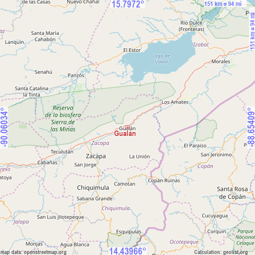
Gualán GPS coordinates[2]
15° 7' 10.272" North, 89° 21' 25.956" West
| Map corner | latitude | longitude |
|---|---|---|
| Upper-left | 15.7972°, | -90.06034° |
| Center: | 15.11952°, | -89.35721° |
| Lower-right: | 14.43966°, | -88.65409° |
| Map W x H: | 150.9×150.9 km | = 93.8×93.8mi |
| max Lat: | 17.06606° ⇑26.5% North |
| Gualán: | 15.11952° |
| min Lat: | ⇓73.5% South 13.9274° |
| min Long | Gualán | max Long |
| -92.19298° | -89.35721° | -88.59444° |
| W 97.3%⇐ | ⇒2.7% E |
Elevation
Elevation of Gualán is 123 m = 404 ft, and this is 1144 m = 3753 ft below average elevation for this country.
| Max E: |
3254 m = 10676 ft | 94.1% |
| Avg. | 1267 m = 4157 ft | |
| Gualán | 123 m = 404 ft | |
Min E: |
1 m = 3 ft | 5.9% |
See also: Guatemala elevation on elevation.city.
Geographical zone
Gualán is located in North Torrid zone (between Equator and Tropic of Cancer). Distance of this Northern Tropic circle is 924.8 km =574.6 mi to North.| Distance of | km | miles | from Gualán |
|---|---|---|---|
| North Pole | 8325.9 | 5173.5 | to North |
| Arctic Circle | 5720 | 3554.2 | to North |
| Tropic Cancer | 924.8 | 574.6 | to North |
| Equator | 1681.1 | 1044.6 | to South |


Nearby cities:
15 places around Gualán: (largest is in red/bold)
• Camotán
33.3 km =20.7 mi,  182°
182°
• Chiquimula
40.9 km =25.4 mi,  209°
209°
• El Estor
46 km =28.6 mi,  0°
0°
• Estanzuela
26.1 km =16.2 mi,  239°
239°
• Huité
43.8 km =27.2 mi, 241°
• Jocotán
33.4 km =20.8 mi,  186°
186°
• La Unión
18.5 km =11.5 mi,  157°
157°
• Los Amates
31.8 km =19.8 mi,  61°
61°
• Olopa
47.5 km =29.5 mi, 179°
• Panzós
45.5 km =28.3 mi,  313°
313°
• Río Hondo
25 km =15.5 mi,  256°
256°
• San Jorge
31.9 km =19.8 mi,  229°
229°
• San Juan Ermita
40.2 km =25 mi, 191°
• Teculután
41.5 km =25.8 mi,  248°
248°
• Zacapa
24.8 km =15.4 mi, 228°
Sources, notices
• [Note1] Compared only with cities in Guatemala existing in our database
• [Src1] Map data: © OpenStreetMap contributors (CC-BY-SA)
• [Src2] Other city data from geonames.org with taken over terms of usage.
• [Src3] Geographical zone / Annual Mean Temperature by Robert A. Rohde @ Wikipedia
