San Juan Ermita geodata
San Juan Ermita (Chiquimula) is a seat of a second-order administrative division; located in Guatemala in America/Guatemala (GMT-6) time zone. With population of 1,623 people, there are 291 cities with bigger population in this country. Compared to other cities in Guatemala, 54% of cities are located further ↑North; 95.9% of cities are located further ←West and 70.8% of cities have higher elevation than San Juan Ermita. Note1


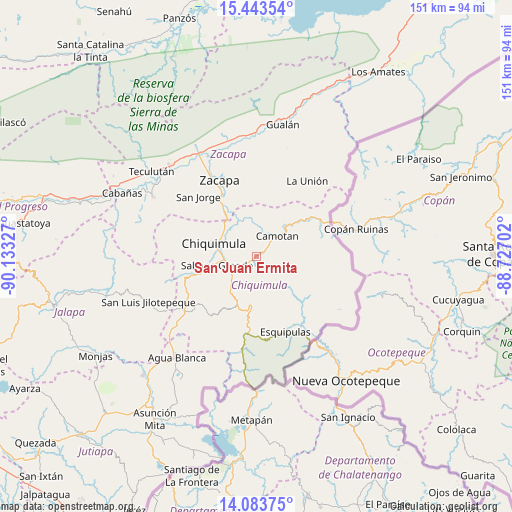
San Juan Ermita GPS coordinates[2]
14° 45' 52.956" North, 89° 25' 48.504" West
| Map corner | latitude | longitude |
|---|---|---|
| Upper-left | 15.44354°, | -90.13327° |
| Center: | 14.76471°, | -89.43014° |
| Lower-right: | 14.08375°, | -88.72702° |
| Map W x H: | 151.2×151.2 km | = 94×94mi |
| max Lat: | 17.06606° ⇑54% North |
| San Juan Ermita: | 14.76471° |
| min Lat: | ⇓46% South 13.9274° |
| min Long | San Juan Ermita | max Long |
| -92.19298° | -89.43014° | -88.59444° |
| W 95.9%⇐ | ⇒4.1% E |
Elevation
Elevation of San Juan Ermita is 602 m = 1975 ft, and this is 665 m = 2182 ft below average elevation for this country.
| Max E: |
3254 m = 10676 ft | 70.8% |
| Avg. | 1267 m = 4157 ft | |
| San Juan Ermita | 602 m = 1975 ft | |
Min E: |
1 m = 3 ft | 29.2% |
See also: Guatemala elevation on elevation.city.
Geographical zone
San Juan Ermita is located in North Torrid zone (between Equator and Tropic of Cancer). Distance of this Northern Tropic circle is 964.2 km =599.1 mi to North.| Distance of | km | miles | from San Juan Ermita |
|---|---|---|---|
| North Pole | 8365.4 | 5198 | to North |
| Arctic Circle | 5759.5 | 3578.8 | to North |
| Tropic Cancer | 964.2 | 599.1 | to North |
| Equator | 1641.7 | 1020.1 | to South |


Nearby cities:
15 places around San Juan Ermita: (largest is in red/bold)
• Camotán
8.8 km =5.5 mi,  45°
45°
• Chiquimula
13 km =8.1 mi,  287°
287°
• Concepción Las Minas
27.2 km =16.9 mi,  186°
186°
• Esquipulas
23.7 km =14.7 mi,  159°
159°
• Estanzuela
30 km =18.6 mi,  330°
330°
• Ipala
26 km =16.2 mi,  230°
230°
• Jocotán
7.6 km =4.7 mi,  34°
34°
• La Unión
27 km =16.8 mi, 33°
• Olopa
11.8 km =7.3 mi,  133°
133°
• Quezaltepeque
14.4 km =8.9 mi, 185°
• San Jacinto
13.2 km =8.2 mi,  214°
214°
• San Jorge
25 km =15.5 mi,  318°
318°
• San José La Arada
17.3 km =10.7 mi,  252°
252°
• San Luis Jilotepeque
35 km =21.7 mi, 248°
• Zacapa
25.5 km =15.8 mi, 334°
Sources, notices
• [Note1] Compared only with cities in Guatemala existing in our database
• [Src1] Map data: © OpenStreetMap contributors (CC-BY-SA)
• [Src2] Other city data from geonames.org with taken over terms of usage.
• [Src3] Geographical zone / Annual Mean Temperature by Robert A. Rohde @ Wikipedia
