Estanzuela geodata
Estanzuela (Zacapa) is a seat of a second-order administrative division; located in Guatemala in America/Guatemala (GMT-6) time zone. With population of 8,937 people, there are 144 cities with bigger population in this country. Compared to other cities in Guatemala, 67% of cities are located further ↓South; 93.8% of cities are located further ←West and 89.4% of cities have higher elevation than Estanzuela. Note1


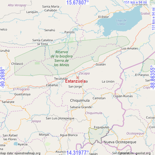
Estanzuela GPS coordinates[2]
15° 0' 0" North, 89° 34' 0.012" West
| Map corner | latitude | longitude |
|---|---|---|
| Upper-left | 15.67807°, | -90.2698° |
| Center: | 15°, | -89.56667° |
| Lower-right: | 14.31977°, | -88.86355° |
| Map W x H: | 151×151 km | = 93.8×93.8mi |
| max Lat: | 17.06606° ⇑33% North |
| Estanzuela: | 15° |
| min Lat: | ⇓67% South 13.9274° |
| min Long | Estanzuela | max Long |
| -92.19298° | -89.56667° | -88.59444° |
| W 93.8%⇐ | ⇒6.2% E |
Elevation
Elevation of Estanzuela is 189 m = 620 ft, and this is 1078 m = 3537 ft below average elevation for this country.
| Max E: |
3254 m = 10676 ft | 89.4% |
| Avg. | 1267 m = 4157 ft | |
| Estanzuela | 189 m = 620 ft | |
Min E: |
1 m = 3 ft | 10.6% |
See also: Guatemala elevation on elevation.city.
Geographical zone
Estanzuela is located in North Torrid zone (between Equator and Tropic of Cancer). Distance of this Northern Tropic circle is 938.1 km =582.9 mi to North.| Distance of | km | miles | from Estanzuela |
|---|---|---|---|
| North Pole | 8339.2 | 5181.7 | to North |
| Arctic Circle | 5733.3 | 3562.5 | to North |
| Tropic Cancer | 938.1 | 582.9 | to North |
| Equator | 1667.8 | 1036.3 | to South |


Nearby cities:
15 places around Estanzuela: (largest is in red/bold)
• Cabañas
26.1 km =16.2 mi,  253°
253°
• Camotán
28.9 km =18 mi,  133°
133°
• Chiquimula
22.4 km =13.9 mi,  174°
174°
• Gualán
26.1 km =16.2 mi,  59°
59°
• Huité
17.7 km =11 mi, 245°
• Jocotán
27.5 km =17.1 mi,  136°
136°
• La Unión
29.9 km =18.6 mi,  97°
97°
• Río Hondo
7.6 km =4.7 mi,  346°
346°
• San Diego
33.5 km =20.8 mi,  224°
224°
• San Jorge
7.6 km =4.7 mi,  193°
193°
• San José La Arada
31.6 km =19.6 mi,  183°
183°
• San Juan Ermita
30 km =18.6 mi,  150°
150°
• Teculután
16.2 km =10.1 mi,  263°
263°
• Usumatlán
23.9 km =14.9 mi, 256°
• Zacapa
5 km =3.1 mi, 128°
Sources, notices
• [Note1] Compared only with cities in Guatemala existing in our database
• [Src1] Map data: © OpenStreetMap contributors (CC-BY-SA)
• [Src2] Other city data from geonames.org with taken over terms of usage.
• [Src3] Geographical zone / Annual Mean Temperature by Robert A. Rohde @ Wikipedia
