Nueva Concepción geodata
Nueva Concepción (Escuintla) is a seat of a second-order administrative division; located in Guatemala in America/Guatemala (GMT-6) time zone. With population of 11,121 people, there are 112 cities with bigger population in this country. Compared to other cities in Guatemala, 95% of cities are located further ↑North; 62.5% of cities are located further →East and 97.1% of cities have higher elevation than Nueva Concepción. Note1


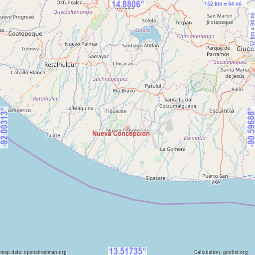
Nueva Concepción GPS coordinates[2]
14° 12' 0" North, 91° 18' 0" West
| Map corner | latitude | longitude |
|---|---|---|
| Upper-left | 14.8806°, | -92.00313° |
| Center: | 14.2°, | -91.3° |
| Lower-right: | 13.51735°, | -90.59688° |
| Map W x H: | 151.6×151.6 km | = 94.2×94.2mi |
| max Lat: | 17.06606° ⇑95% North |
| Nueva Concepción: | 14.2° |
| min Lat: | ⇓5% South 13.9274° |
| min Long | Nueva Concepci� | max Long |
| -92.19298° | -91.3° | -88.59444° |
| W 37.5%⇐ | ⇒62.5% E |
Elevation
Elevation of Nueva Concepción is 58 m = 190 ft, and this is 1209 m = 3967 ft below average elevation for this country.
| Max E: |
3254 m = 10676 ft | 97.1% |
| Avg. | 1267 m = 4157 ft | |
| Nueva Concepción | 58 m = 190 ft | |
Min E: |
1 m = 3 ft | 2.9% |
See also: Guatemala elevation on elevation.city.
Geographical zone
Nueva Concepción is located in North Torrid zone (between Equator and Tropic of Cancer). Distance of this Northern Tropic circle is 1027 km =638.1 mi to North.| Distance of | km | miles | from Nueva Concepción |
|---|---|---|---|
| North Pole | 8428.2 | 5237 | to North |
| Arctic Circle | 5822.3 | 3617.8 | to North |
| Tropic Cancer | 1027 | 638.1 | to North |
| Equator | 1578.9 | 981.1 | to South |


Nearby cities:
15 places around Nueva Concepción: (largest is in red/bold)
• Chicacao
38.2 km =23.7 mi,  355°
355°
• La Democracia
38.2 km =23.7 mi,  84°
84°
• La Gomera
29.6 km =18.4 mi,  116°
116°
• La Máquina
30.9 km =19.2 mi,  291°
291°
• Patulul
29 km =18 mi,  31°
31°
• Río Bravo
22.4 km =13.9 mi, 355°
• San José El Ídolo
30.8 km =19.1 mi,  334°
334°
• San Juan Bautista
28 km =17.4 mi, 27°
• San Lorenzo
39.2 km =24.4 mi,  324°
324°
• San Miguel Panán
37.3 km =23.2 mi,  348°
348°
• Santa Bárbara
27.4 km =17 mi,  16°
16°
• Santa Lucía Cotzumalguapa
33.4 km =20.8 mi,  63°
63°
• Santo Domingo Suchitepéquez
36.8 km =22.9 mi, 327°
• Siquinalá
38 km =23.6 mi,  71°
71°
• Tiquisate
11.4 km =7.1 mi, 324°
Sources, notices
• [Note1] Compared only with cities in Guatemala existing in our database
• [Src1] Map data: © OpenStreetMap contributors (CC-BY-SA)
• [Src2] Other city data from geonames.org with taken over terms of usage.
• [Src3] Geographical zone / Annual Mean Temperature by Robert A. Rohde @ Wikipedia
