Tiquisate geodata
Tiquisate (Escuintla) is a populated place; located in Guatemala in America/Guatemala (GMT-6) time zone. With population of 18,189 people, there are 66 cities with bigger population in this country. Compared to other cities in Guatemala, 92% of cities are located further ↑North; 65.5% of cities are located further →East and 96.5% of cities have higher elevation than Tiquisate. Note1


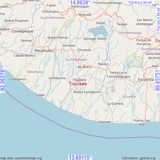
Tiquisate GPS coordinates[2]
14° 17' 0.816" North, 91° 21' 38.268" West
| Map corner | latitude | longitude |
|---|---|---|
| Upper-left | 14.9639°, | -92.06376° |
| Center: | 14.28356°, | -91.36063° |
| Lower-right: | 13.60115°, | -90.65751° |
| Map W x H: | 151.5×151.5 km | = 94.1×94.1mi |
| max Lat: | 17.06606° ⇑92% North |
| Tiquisate: | 14.28356° |
| min Lat: | ⇓8% South 13.9274° |
| min Long | Tiquisate | max Long |
| -92.19298° | -91.36063° | -88.59444° |
| W 34.5%⇐ | ⇒65.5% E |
Elevation
Elevation of Tiquisate is 71 m = 233 ft, and this is 1196 m = 3924 ft below average elevation for this country.
| Max E: |
3254 m = 10676 ft | 96.5% |
| Avg. | 1267 m = 4157 ft | |
| Tiquisate | 71 m = 233 ft | |
Min E: |
1 m = 3 ft | 3.5% |
See also: Guatemala elevation on elevation.city.
Geographical zone
Tiquisate is located in North Torrid zone (between Equator and Tropic of Cancer). Distance of this Northern Tropic circle is 1017.7 km =632.4 mi to North.| Distance of | km | miles | from Tiquisate |
|---|---|---|---|
| North Pole | 8418.9 | 5231.3 | to North |
| Arctic Circle | 5813 | 3612 | to North |
| Tropic Cancer | 1017.7 | 632.4 | to North |
| Equator | 1588.2 | 986.9 | to South |


Nearby cities:
15 places around Tiquisate: (largest is in red/bold)
• Chicacao
29.1 km =18.1 mi,  7°
7°
• La Máquina
22.3 km =13.9 mi,  275°
275°
• Mazatenango
31.8 km =19.8 mi,  331°
331°
• Nueva Concepción
11.4 km =7.1 mi,  144°
144°
• Patulul
26.6 km =16.5 mi,  54°
54°
• Río Bravo
13.8 km =8.6 mi,  19°
19°
• San Antonio Suchitepéquez
29 km =18 mi,  348°
348°
• San Bernardino
30.6 km =19 mi,  339°
339°
• San Gabriel
29.8 km =18.5 mi, 327°
• San José El Ídolo
19.7 km =12.2 mi, 340°
• San Juan Bautista
24.9 km =15.5 mi, 51°
• San Lorenzo
27.8 km =17.3 mi,  323°
323°
• San Miguel Panán
27.3 km =17 mi,  358°
358°
• Santa Bárbara
22.2 km =13.8 mi,  40°
40°
• Santo Domingo Suchitepéquez
25.4 km =15.8 mi, 328°
Sources, notices
• [Note1] Compared only with cities in Guatemala existing in our database
• [Src1] Map data: © OpenStreetMap contributors (CC-BY-SA)
• [Src2] Other city data from geonames.org with taken over terms of usage.
• [Src3] Geographical zone / Annual Mean Temperature by Robert A. Rohde @ Wikipedia
