Patulul geodata
Patulul (Suchitepeque) is a seat of a second-order administrative division; located in Guatemala in America/Guatemala (GMT-6) time zone. With population of 14,196 people, there are 87 cities with bigger population in this country. Compared to other cities in Guatemala, 86.7% of cities are located further ↑North; 58.1% of cities are located further →East and 81.7% of cities have higher elevation than Patulul. Note1


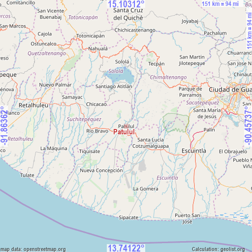
Patulul GPS coordinates[2]
14° 25' 23.556" North, 91° 9' 37.764" West
| Map corner | latitude | longitude |
|---|---|---|
| Upper-left | 15.10312°, | -91.86362° |
| Center: | 14.42321°, | -91.16049° |
| Lower-right: | 13.74122°, | -90.45737° |
| Map W x H: | 151.4×151.4 km | = 94.1×94.1mi |
| max Lat: | 17.06606° ⇑86.7% North |
| Patulul: | 14.42321° |
| min Lat: | ⇓13.3% South 13.9274° |
| min Long | Patulul | max Long |
| -92.19298° | -91.16049° | -88.59444° |
| W 41.9%⇐ | ⇒58.1% E |
Elevation
Elevation of Patulul is 342 m = 1122 ft, and this is 925 m = 3035 ft below average elevation for this country.
| Max E: |
3254 m = 10676 ft | 81.7% |
| Avg. | 1267 m = 4157 ft | |
| Patulul | 342 m = 1122 ft | |
Min E: |
1 m = 3 ft | 18.3% |
See also: Guatemala elevation on elevation.city.
Geographical zone
Patulul is located in North Torrid zone (between Equator and Tropic of Cancer). Distance of this Northern Tropic circle is 1002.2 km =622.7 mi to North.| Distance of | km | miles | from Patulul |
|---|---|---|---|
| North Pole | 8403.4 | 5221.6 | to North |
| Arctic Circle | 5797.5 | 3602.4 | to North |
| Tropic Cancer | 1002.2 | 622.7 | to North |
| Equator | 1603.7 | 996.5 | to South |


Nearby cities:
15 places around Patulul: (largest is in red/bold)
• Acatenango
27.5 km =17.1 mi,  57°
57°
• Chicacao
22.3 km =13.9 mi,  306°
306°
• Nueva Concepción
29 km =18 mi,  211°
211°
• Pochuta
15.5 km =9.6 mi,  29°
29°
• Río Bravo
17.1 km =10.6 mi,  261°
261°
• San José El Ídolo
28.3 km =17.6 mi,  276°
276°
• San Juan Bautista
2 km =1.2 mi,  268°
268°
• San Lucas Tolimán
19.1 km =11.9 mi,  4°
4°
• San Miguel Panán
25.2 km =15.7 mi,  297°
297°
• Santa Bárbara
7.3 km =4.5 mi, 280°
• Santa Lucía Cotzumalguapa
17.7 km =11 mi,  123°
123°
• Santiago Atitlán
25 km =15.5 mi,  342°
342°
• Siquinalá
24.8 km =15.4 mi, 121°
• Tiquisate
26.6 km =16.5 mi,  234°
234°
• Yepocapa
23.9 km =14.9 mi,  68°
68°
Sources, notices
• [Note1] Compared only with cities in Guatemala existing in our database
• [Src1] Map data: © OpenStreetMap contributors (CC-BY-SA)
• [Src2] Other city data from geonames.org with taken over terms of usage.
• [Src3] Geographical zone / Annual Mean Temperature by Robert A. Rohde @ Wikipedia
