La Gomera geodata
La Gomera (Escuintla) is a seat of a second-order administrative division; located in Guatemala in America/Guatemala (GMT-6) time zone. With population of 24,001 people, there are 46 cities with bigger population in this country. Compared to other cities in Guatemala, 97.9% of cities are located further ↑North; 53.4% of cities are located further →East and 97.3% of cities have higher elevation than La Gomera. Note1


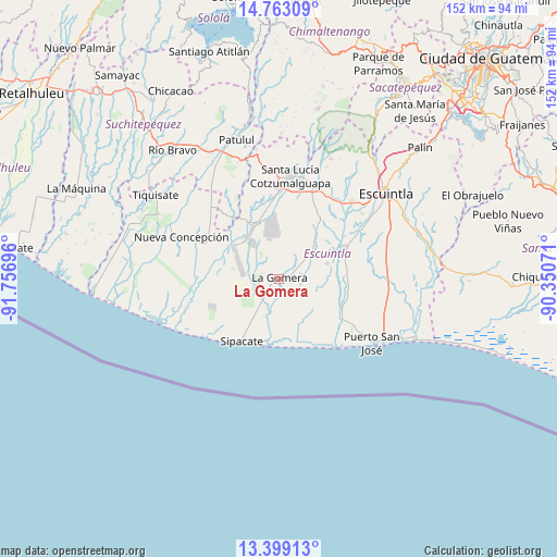
La Gomera GPS coordinates[2]
14° 4' 55.668" North, 91° 3' 13.788" West
| Map corner | latitude | longitude |
|---|---|---|
| Upper-left | 14.76309°, | -91.75696° |
| Center: | 14.08213°, | -91.05383° |
| Lower-right: | 13.39913°, | -90.35071° |
| Map W x H: | 151.7×151.7 km | = 94.3×94.3mi |
| max Lat: | 17.06606° ⇑97.9% North |
| La Gomera: | 14.08213° |
| min Lat: | ⇓2.1% South 13.9274° |
| min Long | La Gomera | max Long |
| -92.19298° | -91.05383° | -88.59444° |
| W 46.6%⇐ | ⇒53.4% E |
Elevation
Elevation of La Gomera is 38 m = 125 ft, and this is 1229 m = 4032 ft below average elevation for this country.
| Max E: |
3254 m = 10676 ft | 97.3% |
| Avg. | 1267 m = 4157 ft | |
| La Gomera | 38 m = 125 ft | |
Min E: |
1 m = 3 ft | 2.7% |
See also: Guatemala elevation on elevation.city.
Geographical zone
La Gomera is located in North Torrid zone (between Equator and Tropic of Cancer). Distance of this Northern Tropic circle is 1040.1 km =646.3 mi to North.| Distance of | km | miles | from La Gomera |
|---|---|---|---|
| North Pole | 8441.3 | 5245.2 | to North |
| Arctic Circle | 5835.4 | 3625.9 | to North |
| Tropic Cancer | 1040.1 | 646.3 | to North |
| Equator | 1565.8 | 972.9 | to South |


Nearby cities:
15 places around La Gomera: (largest is in red/bold)
• Escuintla
38.1 km =23.7 mi,  49°
49°
• Guanagazapa
47 km =29.2 mi,  70°
70°
• Iztapa
40.9 km =25.4 mi,  113°
113°
• La Democracia
20.1 km =12.5 mi,  34°
34°
• Masagua
25.9 km =16.1 mi,  58°
58°
• Nueva Concepción
29.6 km =18.4 mi,  296°
296°
• Patulul
39.6 km =24.6 mi,  343°
343°
• Puerto San José
30.4 km =18.9 mi,  124°
124°
• Río Bravo
45.4 km =28.2 mi,  321°
321°
• San Juan Bautista
40.2 km =25 mi, 340°
• Santa Bárbara
43.5 km =27 mi,  334°
334°
• Santa Lucía Cotzumalguapa
28.3 km =17.6 mi,  6°
6°
• Siquinalá
26.7 km =16.6 mi,  21°
21°
• Tiquisate
39.9 km =24.8 mi, 304°
• Yepocapa
47.9 km =29.8 mi, 12°
Sources, notices
• [Note1] Compared only with cities in Guatemala existing in our database
• [Src1] Map data: © OpenStreetMap contributors (CC-BY-SA)
• [Src2] Other city data from geonames.org with taken over terms of usage.
• [Src3] Geographical zone / Annual Mean Temperature by Robert A. Rohde @ Wikipedia
