La Democracia geodata
La Democracia (Escuintla) is a seat of a second-order administrative division; located in Guatemala in America/Guatemala (GMT-6) time zone. With population of 5,479 people, there are 198 cities with bigger population in this country. Compared to other cities in Guatemala, 93.2% of cities are located further ↑North; 50.1% of cities are located further →East and 91.7% of cities have higher elevation than La Democracia. Note1


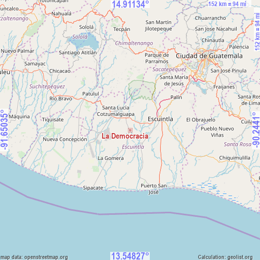
La Democracia GPS coordinates[2]
14° 13' 50.988" North, 90° 56' 49.992" West
| Map corner | latitude | longitude |
|---|---|---|
| Upper-left | 14.91134°, | -91.65035° |
| Center: | 14.23083°, | -90.94722° |
| Lower-right: | 13.54827°, | -90.2441° |
| Map W x H: | 151.6×151.6 km | = 94.2×94.2mi |
| max Lat: | 17.06606° ⇑93.2% North |
| La Democracia: | 14.23083° |
| min Lat: | ⇓6.8% South 13.9274° |
| min Long | La Democracia | max Long |
| -92.19298° | -90.94722° | -88.59444° |
| W 49.9%⇐ | ⇒50.1% E |
Elevation
Elevation of La Democracia is 168 m = 551 ft, and this is 1099 m = 3606 ft below average elevation for this country.
| Max E: |
3254 m = 10676 ft | 91.7% |
| Avg. | 1267 m = 4157 ft | |
| La Democracia | 168 m = 551 ft | |
Min E: |
1 m = 3 ft | 8.3% |
See also: Guatemala elevation on elevation.city.
Geographical zone
La Democracia is located in North Torrid zone (between Equator and Tropic of Cancer). Distance of this Northern Tropic circle is 1023.6 km =636 mi to North.| Distance of | km | miles | from La Democracia |
|---|---|---|---|
| North Pole | 8424.7 | 5234.9 | to North |
| Arctic Circle | 5818.9 | 3615.7 | to North |
| Tropic Cancer | 1023.6 | 636 | to North |
| Equator | 1582.3 | 983.2 | to South |


Nearby cities:
15 places around La Democracia: (largest is in red/bold)
• Acatenango
36 km =22.4 mi,  0°
0°
• Alotenango
31.6 km =19.6 mi,  28°
28°
• Escuintla
19.3 km =12 mi,  64°
64°
• Guanagazapa
32.8 km =20.4 mi,  91°
91°
• La Gomera
20.1 km =12.5 mi,  214°
214°
• Masagua
11.1 km =6.9 mi,  106°
106°
• Palín
33.1 km =20.6 mi,  54°
54°
• Patulul
31.4 km =19.5 mi,  312°
312°
• Puerto San José
36.4 km =22.6 mi,  158°
158°
• San Juan Bautista
32.8 km =20.4 mi, 310°
• San Miguel Dueñas
36.1 km =22.4 mi, 26°
• Santa Bárbara
37.8 km =23.5 mi, 307°
• Santa Lucía Cotzumalguapa
14.2 km =8.8 mi,  324°
324°
• Siquinalá
8.6 km =5.3 mi,  347°
347°
• Yepocapa
30.2 km =18.8 mi,  358°
358°
Sources, notices
• [Note1] Compared only with cities in Guatemala existing in our database
• [Src1] Map data: © OpenStreetMap contributors (CC-BY-SA)
• [Src2] Other city data from geonames.org with taken over terms of usage.
• [Src3] Geographical zone / Annual Mean Temperature by Robert A. Rohde @ Wikipedia
