Mataquescuintla geodata
Mataquescuintla (Jalapa) is a seat of a second-order administrative division; located in Guatemala in America/Guatemala (GMT-6) time zone. With population of 7,539 people, there are 166 cities with bigger population in this country. Compared to other cities in Guatemala, 79.4% of cities are located further ↑North; 77% of cities are located further ←West and 64.9% of cities have lower elevation than Mataquescuintla. Note1


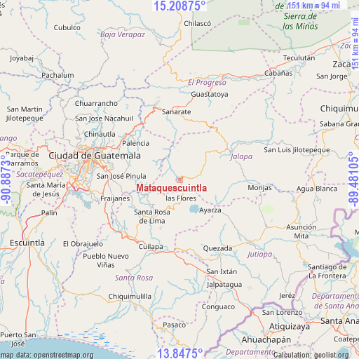
Mataquescuintla GPS coordinates[2]
14° 31' 45.012" North, 90° 11' 3.012" West
| Map corner | latitude | longitude |
|---|---|---|
| Upper-left | 15.20875°, | -90.8873° |
| Center: | 14.52917°, | -90.18417° |
| Lower-right: | 13.8475°, | -89.48105° |
| Map W x H: | 151.4×151.4 km | = 94.1×94.1mi |
| max Lat: | 17.06606° ⇑79.4% North |
| Mataquescuintla: | 14.52917° |
| min Lat: | ⇓20.6% South 13.9274° |
| min Long | Mataquescuintla | max Long |
| -92.19298° | -90.18417° | -88.59444° |
| W 77%⇐ | ⇒23% E |
Elevation
Elevation of Mataquescuintla is 1641 m = 5384 ft, and this is 374 m = 1227 ft above average elevation for this country.
| Max E: |
3254 m = 10676 ft | 35.1% |
| Mataquescuintla | 1641 m 5384 ft | |
| Avg. | 1267 m = 4157 ft | |
Min E: |
1 m = 3 ft | 64.9% |
See also: Guatemala elevation on elevation.city.
Geographical zone
Mataquescuintla is located in North Torrid zone (between Equator and Tropic of Cancer). Distance of this Northern Tropic circle is 990.4 km =615.4 mi to North.| Distance of | km | miles | from Mataquescuintla |
|---|---|---|---|
| North Pole | 8391.6 | 5214.3 | to North |
| Arctic Circle | 5785.7 | 3595.1 | to North |
| Tropic Cancer | 990.4 | 615.4 | to North |
| Equator | 1615.5 | 1003.8 | to South |


Nearby cities:
15 places around Mataquescuintla: (largest is in red/bold)
• Casillas
13.8 km =8.6 mi,  207°
207°
• Cuilapa
30.7 km =19.1 mi,  203°
203°
• Fraijanes
28.5 km =17.7 mi,  255°
255°
• Jalapa
24.1 km =15 mi,  60°
60°
• Nueva Santa Rosa
19.2 km =11.9 mi, 211°
• Palencia
24.1 km =15 mi,  309°
309°
• San Antonio La Paz
27.7 km =17.2 mi,  337°
337°
• San Carlos Alzatate
13.8 km =8.6 mi,  104°
104°
• San José Acatempa
30 km =18.6 mi,  168°
168°
• San José Pinula
24.7 km =15.3 mi,  274°
274°
• San Rafael Las Flores
5.9 km =3.7 mi, 174°
• Sanarate
28.9 km =18 mi,  356°
356°
• Sansare
25.2 km =15.7 mi,  16°
16°
• Santa Cruz Naranjo
25.4 km =15.8 mi,  231°
231°
• Santa Rosa de Lima
19.7 km =12.2 mi,  217°
217°
Sources, notices
• [Note1] Compared only with cities in Guatemala existing in our database
• [Src1] Map data: © OpenStreetMap contributors (CC-BY-SA)
• [Src2] Other city data from geonames.org with taken over terms of usage.
• [Src3] Geographical zone / Annual Mean Temperature by Robert A. Rohde @ Wikipedia
