Colomba geodata
Colomba (Quetzaltenango) is a seat of a second-order administrative division; located in Guatemala in America/Guatemala (GMT-6) time zone. With population of 19,115 people, there are 60 cities with bigger population in this country. Compared to other cities in Guatemala, 59.3% of cities are located further ↑North; 87.6% of cities are located further →East and 58.1% of cities have higher elevation than Colomba. Note1


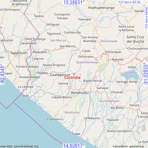
Colomba GPS coordinates[2]
14° 42' 26.28" North, 91° 43' 54.012" West
| Map corner | latitude | longitude |
|---|---|---|
| Upper-left | 15.38631°, | -92.4348° |
| Center: | 14.7073°, | -91.73167° |
| Lower-right: | 14.02617°, | -91.02855° |
| Map W x H: | 151.2×151.2 km | = 94×94mi |
| max Lat: | 17.06606° ⇑59.3% North |
| Colomba: | 14.7073° |
| min Lat: | ⇓40.7% South 13.9274° |
| min Long | Colomba | max Long |
| -92.19298° | -91.73167° | -88.59444° |
| W 12.4%⇐ | ⇒87.6% E |
Elevation
Elevation of Colomba is 991 m = 3251 ft, and this is 276 m = 906 ft below average elevation for this country.
| Max E: |
3254 m = 10676 ft | 58.1% |
| Avg. | 1267 m = 4157 ft | |
| Colomba | 991 m = 3251 ft | |
Min E: |
1 m = 3 ft | 41.9% |
See also: Guatemala elevation on elevation.city.
Geographical zone
Colomba is located in North Torrid zone (between Equator and Tropic of Cancer). Distance of this Northern Tropic circle is 970.6 km =603.1 mi to North.| Distance of | km | miles | from Colomba |
|---|---|---|---|
| North Pole | 8371.8 | 5202 | to North |
| Arctic Circle | 5765.9 | 3582.8 | to North |
| Tropic Cancer | 970.6 | 603.1 | to North |
| Equator | 1635.3 | 1016.1 | to South |


Nearby cities:
15 places around Colomba: (largest is in red/bold)
• Coatepeque
14.3 km =8.9 mi,  268°
268°
• El Asintal
12.4 km =7.7 mi,  177°
177°
• El Palmar
17.7 km =11 mi,  110°
110°
• El Quetzal
11.5 km =7.1 mi,  306°
306°
• Flores Costa Cuca
16.4 km =10.2 mi,  239°
239°
• Génova
14.9 km =9.3 mi,  227°
227°
• La Reforma
14.3 km =8.9 mi,  316°
316°
• Nuevo San Carlos
13.3 km =8.3 mi,  162°
162°
• Retalhuleu
19.9 km =12.4 mi, 163°
• San Felipe
17.4 km =10.8 mi,  122°
122°
• San Juan Ostuncalco
19 km =11.8 mi,  13°
13°
• San Martín Sacatepéquez
16.2 km =10.1 mi,  36°
36°
• San Martín Zapotitlán
17.4 km =10.8 mi,  129°
129°
• San Sebastián
18.5 km =11.5 mi,  151°
151°
• Santa Cruz Muluá
18.1 km =11.2 mi,  140°
140°
Sources, notices
• [Note1] Compared only with cities in Guatemala existing in our database
• [Src1] Map data: © OpenStreetMap contributors (CC-BY-SA)
• [Src2] Other city data from geonames.org with taken over terms of usage.
• [Src3] Geographical zone / Annual Mean Temperature by Robert A. Rohde @ Wikipedia
