Chicamán geodata
Chicamán (Quiché) is a seat of a second-order administrative division; located in Guatemala in America/Guatemala (GMT-6) time zone. With population of 2,090 people, there are 274 cities with bigger population in this country. Compared to other cities in Guatemala, 81.7% of cities are located further ↓South; 55.2% of cities are located further ←West and 56.6% of cities have lower elevation than Chicamán. Note1


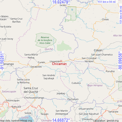
Chicamán GPS coordinates[2]
15° 20' 52.296" North, 90° 47' 58.848" West
| Map corner | latitude | longitude |
|---|---|---|
| Upper-left | 16.02479°, | -91.50281° |
| Center: | 15.34786°, | -90.79968° |
| Lower-right: | 14.66872°, | -90.09656° |
| Map W x H: | 150.8×150.8 km | = 93.7×93.7mi |
| max Lat: | 17.06606° ⇑18.3% North |
| Chicamán: | 15.34786° |
| min Lat: | ⇓81.7% South 13.9274° |
| min Long | Chicamán | max Long |
| -92.19298° | -90.79968° | -88.59444° |
| W 55.2%⇐ | ⇒44.8% E |
Elevation
Elevation of Chicamán is 1452 m = 4764 ft, and this is 185 m = 607 ft above average elevation for this country.
| Max E: |
3254 m = 10676 ft | 43.4% |
| Chicamán | 1452 m 4764 ft | |
| Avg. | 1267 m = 4157 ft | |
Min E: |
1 m = 3 ft | 56.6% |
See also: Guatemala elevation on elevation.city.
Geographical zone
Chicamán is located in North Torrid zone (between Equator and Tropic of Cancer). Distance of this Northern Tropic circle is 899.4 km =558.9 mi to North.| Distance of | km | miles | from Chicamán |
|---|---|---|---|
| North Pole | 8300.5 | 5157.7 | to North |
| Arctic Circle | 5694.7 | 3538.5 | to North |
| Tropic Cancer | 899.4 | 558.9 | to North |
| Equator | 1706.5 | 1060.4 | to South |


Nearby cities:
15 places around Chicamán: (largest is in red/bold)
• Canillá
21.1 km =13.1 mi,  195°
195°
• Chajul
29.5 km =18.3 mi,  301°
301°
• Chinique
41.8 km =26 mi,  215°
215°
• Cubulco
32.7 km =20.3 mi,  145°
145°
• Cunén
24.5 km =15.2 mi,  266°
266°
• Joyabaj
39.4 km =24.5 mi,  180°
180°
• Nebaj
37.8 km =23.5 mi,  279°
279°
• Sacapulas
31.7 km =19.7 mi,  257°
257°
• San Andrés Sajcabajá
24.5 km =15.2 mi, 218°
• San Bartolomé Jocotenango
34.6 km =21.5 mi,  239°
239°
• San Cristóbal Verapaz
25.7 km =16 mi,  77°
77°
• San Juan Cotzal
27 km =16.8 mi,  290°
290°
• Santa Cruz Verapaz
39.3 km =24.4 mi,  86°
86°
• Uspantán
7.6 km =4.7 mi, 269°
• Zacualpa
36.7 km =22.8 mi,  193°
193°
Sources, notices
• [Note1] Compared only with cities in Guatemala existing in our database
• [Src1] Map data: © OpenStreetMap contributors (CC-BY-SA)
• [Src2] Other city data from geonames.org with taken over terms of usage.
• [Src3] Geographical zone / Annual Mean Temperature by Robert A. Rohde @ Wikipedia
