Santa Cruz Verapaz geodata
Santa Cruz Verapaz (Alta Verapaz) is a seat of a second-order administrative division; located in Guatemala in America/Guatemala (GMT-6) time zone. With population of 5,843 people, there are 191 cities with bigger population in this country. Compared to other cities in Guatemala, 82.3% of cities are located further ↓South; 68.7% of cities are located further ←West and 56.3% of cities have lower elevation than Santa Cruz Verapaz. Note1


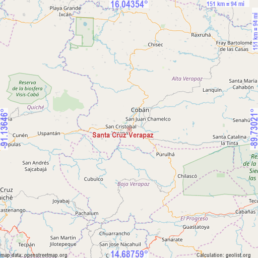
Santa Cruz Verapaz GPS coordinates[2]
15° 22' 0.012" North, 90° 25' 59.988" West
| Map corner | latitude | longitude |
|---|---|---|
| Upper-left | 16.04354°, | -91.13646° |
| Center: | 15.36667°, | -90.43333° |
| Lower-right: | 14.68759°, | -89.73021° |
| Map W x H: | 150.8×150.8 km | = 93.7×93.7mi |
| max Lat: | 17.06606° ⇑17.7% North |
| Santa Cruz Verapaz: | 15.36667° |
| min Lat: | ⇓82.3% South 13.9274° |
| min Long | Santa Cruz Vera | max Long |
| -92.19298° | -90.43333° | -88.59444° |
| W 68.7%⇐ | ⇒31.3% E |
Elevation
Elevation of Santa Cruz Verapaz is 1420 m = 4659 ft, and this is 153 m = 502 ft above average elevation for this country.
| Max E: |
3254 m = 10676 ft | 43.7% |
| Santa Cruz Verapaz | 1420 m 4659 ft | |
| Avg. | 1267 m = 4157 ft | |
Min E: |
1 m = 3 ft | 56.3% |
See also: Guatemala elevation on elevation.city.
Geographical zone
Santa Cruz Verapaz is located in North Torrid zone (between Equator and Tropic of Cancer). Distance of this Northern Tropic circle is 897.3 km =557.6 mi to North.| Distance of | km | miles | from Santa Cruz Verapaz |
|---|---|---|---|
| North Pole | 8298.4 | 5156.4 | to North |
| Arctic Circle | 5692.6 | 3537.2 | to North |
| Tropic Cancer | 897.3 | 557.6 | to North |
| Equator | 1708.6 | 1061.7 | to South |


Nearby cities:
15 places around Santa Cruz Verapaz: (largest is in red/bold)
• Chicamán
39.3 km =24.4 mi,  266°
266°
• Cobán
13.4 km =8.3 mi,  30°
30°
• Cubulco
35.9 km =22.3 mi,  215°
215°
• El Chol
45.5 km =28.3 mi,  187°
187°
• Purulhá
27.4 km =17 mi,  113°
113°
• Rabinal
31.9 km =19.8 mi, 191°
• Salamá
31.8 km =19.8 mi,  157°
157°
• San Cristóbal Verapaz
14.5 km =9 mi,  283°
283°
• San Jerónimo
39.9 km =24.8 mi,  148°
148°
• San Juan Chamelco
13 km =8.1 mi,  55°
55°
• San Miguel Chicaj
30.5 km =19 mi,  172°
172°
• San Pedro Carchá
22.1 km =13.7 mi,  54°
54°
• Tactic
9.8 km =6.1 mi,  120°
120°
• Tamahú
22.1 km =13.7 mi, 106°
• Tucurú
40 km =24.9 mi,  100°
100°
Sources, notices
• [Note1] Compared only with cities in Guatemala existing in our database
• [Src1] Map data: © OpenStreetMap contributors (CC-BY-SA)
• [Src2] Other city data from geonames.org with taken over terms of usage.
• [Src3] Geographical zone / Annual Mean Temperature by Robert A. Rohde @ Wikipedia
