Cubulco geodata
Cubulco (Baja Verapaz) is a seat of a second-order administrative division; located in Guatemala in America/Guatemala (GMT-6) time zone. With population of 9,753 people, there are 131 cities with bigger population in this country. Compared to other cities in Guatemala, 73.2% of cities are located further ↓South; 63.4% of cities are located further ←West and 56.9% of cities have higher elevation than Cubulco. Note1


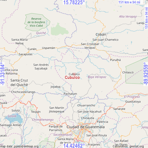
Cubulco GPS coordinates[2]
15° 6' 16.272" North, 90° 37' 43.356" West
| Map corner | latitude | longitude |
|---|---|---|
| Upper-left | 15.78225°, | -91.33184° |
| Center: | 15.10452°, | -90.62871° |
| Lower-right: | 14.42462°, | -89.92559° |
| Map W x H: | 151×151 km | = 93.8×93.8mi |
| max Lat: | 17.06606° ⇑26.8% North |
| Cubulco: | 15.10452° |
| min Lat: | ⇓73.2% South 13.9274° |
| min Long | Cubulco | max Long |
| -92.19298° | -90.62871° | -88.59444° |
| W 63.4%⇐ | ⇒36.6% E |
Elevation
Elevation of Cubulco is 1015 m = 3330 ft, and this is 252 m = 827 ft below average elevation for this country.
| Max E: |
3254 m = 10676 ft | 56.9% |
| Avg. | 1267 m = 4157 ft | |
| Cubulco | 1015 m = 3330 ft | |
Min E: |
1 m = 3 ft | 43.1% |
See also: Guatemala elevation on elevation.city.
Geographical zone
Cubulco is located in North Torrid zone (between Equator and Tropic of Cancer). Distance of this Northern Tropic circle is 926.5 km =575.7 mi to North.| Distance of | km | miles | from Cubulco |
|---|---|---|---|
| North Pole | 8327.6 | 5174.5 | to North |
| Arctic Circle | 5721.7 | 3555.3 | to North |
| Tropic Cancer | 926.5 | 575.7 | to North |
| Equator | 1679.5 | 1043.6 | to South |


Nearby cities:
15 places around Cubulco: (largest is in red/bold)
• Canillá
25 km =15.5 mi,  285°
285°
• Chicamán
32.7 km =20.3 mi,  325°
325°
• Chuarrancho
34.1 km =21.2 mi,  159°
159°
• El Chol
22 km =13.7 mi,  136°
136°
• Granados
23.8 km =14.8 mi,  151°
151°
• Joyabaj
22.3 km =13.9 mi,  236°
236°
• Pachalum
20.3 km =12.6 mi,  190°
190°
• Rabinal
14.8 km =9.2 mi,  98°
98°
• Salamá
33.3 km =20.7 mi,  90°
90°
• San Andrés Sajcabajá
34.6 km =21.5 mi,  283°
283°
• San Cristóbal Verapaz
33.2 km =20.6 mi,  11°
11°
• San Miguel Chicaj
25.2 km =15.7 mi, 92°
• Santa Cruz Verapaz
35.9 km =22.3 mi,  35°
35°
• Uspantán
37.4 km =23.2 mi,  316°
316°
• Zacualpa
28.1 km =17.5 mi,  252°
252°
Sources, notices
• [Note1] Compared only with cities in Guatemala existing in our database
• [Src1] Map data: © OpenStreetMap contributors (CC-BY-SA)
• [Src2] Other city data from geonames.org with taken over terms of usage.
• [Src3] Geographical zone / Annual Mean Temperature by Robert A. Rohde @ Wikipedia
