Canillá geodata
Canillá (Quiché) is a seat of a second-order administrative division; located in Guatemala in America/Guatemala (GMT-6) time zone. With population of 1,698 people, there are 285 cities with bigger population in this country. Compared to other cities in Guatemala, 74.9% of cities are located further ↓South; 52.8% of cities are located further ←West and 50.4% of cities have higher elevation than Canillá. Note1


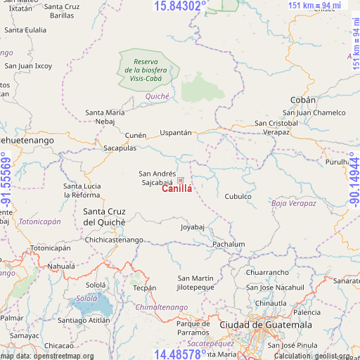
Canillá GPS coordinates[2]
15° 9' 55.764" North, 90° 51' 9.216" West
| Map corner | latitude | longitude |
|---|---|---|
| Upper-left | 15.84302°, | -91.55569° |
| Center: | 15.16549°, | -90.85256° |
| Lower-right: | 14.48578°, | -90.14944° |
| Map W x H: | 150.9×150.9 km | = 93.8×93.8mi |
| max Lat: | 17.06606° ⇑25.1% North |
| Canillá: | 15.16549° |
| min Lat: | ⇓74.9% South 13.9274° |
| min Long | Canillá | max Long |
| -92.19298° | -90.85256° | -88.59444° |
| W 52.8%⇐ | ⇒47.2% E |
Elevation
Elevation of Canillá is 1252 m = 4108 ft, and this is 15 m = 49 ft below average elevation for this country.
| Max E: |
3254 m = 10676 ft | 50.4% |
| Avg. | 1267 m = 4157 ft | |
| Canillá | 1252 m = 4108 ft | |
Min E: |
1 m = 3 ft | 49.6% |
See also: Guatemala elevation on elevation.city.
Geographical zone
Canillá is located in North Torrid zone (between Equator and Tropic of Cancer). Distance of this Northern Tropic circle is 919.7 km =571.5 mi to North.| Distance of | km | miles | from Canillá |
|---|---|---|---|
| North Pole | 8320.8 | 5170.3 | to North |
| Arctic Circle | 5714.9 | 3551.1 | to North |
| Tropic Cancer | 919.7 | 571.5 | to North |
| Equator | 1686.2 | 1047.8 | to South |


Nearby cities:
15 places around Canillá: (largest is in red/bold)
• Chicamán
21.1 km =13.1 mi,  15°
15°
• Chiché
28.6 km =17.8 mi,  232°
232°
• Chinique
23.2 km =14.4 mi, 233°
• Cubulco
25 km =15.5 mi,  105°
105°
• Cunén
26.7 km =16.6 mi,  315°
315°
• Joyabaj
19.9 km =12.4 mi,  164°
164°
• Pachalum
33.6 km =20.9 mi,  142°
142°
• Sacapulas
28.8 km =17.9 mi,  298°
298°
• San Andrés Sajcabajá
9.7 km =6 mi,  276°
276°
• San Bartolomé Jocotenango
24.4 km =15.2 mi, 276°
• San Juan Cotzal
35.7 km =22.2 mi,  326°
326°
• San Pédro Jocopilas
33 km =20.5 mi,  256°
256°
• Santa Cruz del Quiché
35.1 km =21.8 mi,  244°
244°
• Uspantán
20.2 km =12.6 mi,  354°
354°
• Zacualpa
15.7 km =9.8 mi,  190°
190°
Sources, notices
• [Note1] Compared only with cities in Guatemala existing in our database
• [Src1] Map data: © OpenStreetMap contributors (CC-BY-SA)
• [Src2] Other city data from geonames.org with taken over terms of usage.
• [Src3] Geographical zone / Annual Mean Temperature by Robert A. Rohde @ Wikipedia
