Joyabaj geodata
Joyabaj (Quiché) is a seat of a second-order administrative division; located in Guatemala in America/Guatemala (GMT-6) time zone. With population of 13,164 people, there are 95 cities with bigger population in this country. Compared to other cities in Guatemala, 66.4% of cities are located further ↓South; 54.9% of cities are located further ←West and 55.8% of cities have lower elevation than Joyabaj. Note1


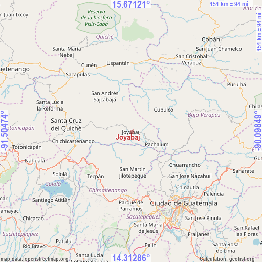
Joyabaj GPS coordinates[2]
14° 59' 35.196" North, 90° 48' 5.796" West
| Map corner | latitude | longitude |
|---|---|---|
| Upper-left | 15.67121°, | -91.50474° |
| Center: | 14.99311°, | -90.80161° |
| Lower-right: | 14.31286°, | -90.09849° |
| Map W x H: | 151×151 km | = 93.8×93.8mi |
| max Lat: | 17.06606° ⇑33.6% North |
| Joyabaj: | 14.99311° |
| min Lat: | ⇓66.4% South 13.9274° |
| min Long | Joyabaj | max Long |
| -92.19298° | -90.80161° | -88.59444° |
| W 54.9%⇐ | ⇒45.1% E |
Elevation
Elevation of Joyabaj is 1405 m = 4610 ft, and this is 138 m = 453 ft above average elevation for this country.
| Max E: |
3254 m = 10676 ft | 44.2% |
| Joyabaj | 1405 m 4610 ft | |
| Avg. | 1267 m = 4157 ft | |
Min E: |
1 m = 3 ft | 55.8% |
See also: Guatemala elevation on elevation.city.
Geographical zone
Joyabaj is located in North Torrid zone (between Equator and Tropic of Cancer). Distance of this Northern Tropic circle is 938.8 km =583.3 mi to North.| Distance of | km | miles | from Joyabaj |
|---|---|---|---|
| North Pole | 8340 | 5182.2 | to North |
| Arctic Circle | 5734.1 | 3563 | to North |
| Tropic Cancer | 938.8 | 583.3 | to North |
| Equator | 1667.1 | 1035.9 | to South |


Nearby cities:
15 places around Joyabaj: (largest is in red/bold)
• Canillá
19.9 km =12.4 mi,  344°
344°
• Chichicastenango
33.7 km =20.9 mi,  260°
260°
• Chiché
28.2 km =17.5 mi,  273°
273°
• Chinique
24.7 km =15.3 mi,  282°
282°
• Comalapa
29.5 km =18.3 mi,  198°
198°
• Cubulco
22.3 km =13.9 mi,  56°
56°
• Granados
31.1 km =19.3 mi,  105°
105°
• Pachalum
16.7 km =10.4 mi,  117°
117°
• San Andrés Sajcabajá
25.3 km =15.7 mi,  323°
323°
• San José Poaquil
22.8 km =14.2 mi,  211°
211°
• San Martín Jilotepeque
23.7 km =14.7 mi,  177°
177°
• San Raimundo
33.7 km =20.9 mi,  138°
138°
• Santa Apolonia
29.1 km =18.1 mi,  219°
219°
• Tecpán Guatemala
32.9 km =20.4 mi, 218°
• Zacualpa
9 km =5.6 mi,  294°
294°
Sources, notices
• [Note1] Compared only with cities in Guatemala existing in our database
• [Src1] Map data: © OpenStreetMap contributors (CC-BY-SA)
• [Src2] Other city data from geonames.org with taken over terms of usage.
• [Src3] Geographical zone / Annual Mean Temperature by Robert A. Rohde @ Wikipedia
