Chajul geodata
Chajul (Quiché) is a seat of a second-order administrative division; located in Guatemala in America/Guatemala (GMT-6) time zone. With population of 11,657 people, there are 108 cities with bigger population in this country. Compared to other cities in Guatemala, 87.6% of cities are located further ↓South; 53.1% of cities are located further →East and 74.9% of cities have lower elevation than Chajul. Note1


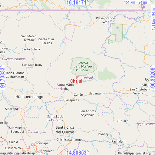
Chajul GPS coordinates[2]
15° 29' 6.828" North, 91° 2' 6.72" West
| Map corner | latitude | longitude |
|---|---|---|
| Upper-left | 16.16171°, | -91.73833° |
| Center: | 15.48523°, | -91.0352° |
| Lower-right: | 14.80653°, | -90.33208° |
| Map W x H: | 150.7×150.7 km | = 93.6×93.6mi |
| max Lat: | 17.06606° ⇑12.4% North |
| Chajul: | 15.48523° |
| min Lat: | ⇓87.6% South 13.9274° |
| min Long | Chajul | max Long |
| -92.19298° | -91.0352° | -88.59444° |
| W 46.9%⇐ | ⇒53.1% E |
Elevation
Elevation of Chajul is 1987 m = 6519 ft, and this is 720 m = 2362 ft above average elevation for this country.
| Max E: |
3254 m = 10676 ft | 25.1% |
| Chajul | 1987 m 6519 ft | |
| Avg. | 1267 m = 4157 ft | |
Min E: |
1 m = 3 ft | 74.9% |
See also: Guatemala elevation on elevation.city.
Geographical zone
Chajul is located in North Torrid zone (between Equator and Tropic of Cancer). Distance of this Northern Tropic circle is 884.1 km =549.4 mi to North.| Distance of | km | miles | from Chajul |
|---|---|---|---|
| North Pole | 8285.3 | 5148.2 | to North |
| Arctic Circle | 5679.4 | 3529 | to North |
| Tropic Cancer | 884.1 | 549.4 | to North |
| Equator | 1721.8 | 1069.9 | to South |


Nearby cities:
15 places around Chajul: (largest is in red/bold)
• Aguacatán
33.6 km =20.9 mi,  241°
241°
• Barillas
46.4 km =28.8 mi,  319°
319°
• Canillá
40.6 km =25.2 mi,  151°
151°
• Chicamán
29.5 km =18.3 mi,  121°
121°
• Cunén
16.6 km =10.3 mi,  177°
177°
• Nebaj
14.8 km =9.2 mi,  233°
233°
• Sacapulas
22.7 km =14.1 mi,  194°
194°
• San Andrés Sajcabajá
35.8 km =22.2 mi,  163°
163°
• San Bartolomé Jocotenango
33 km =20.5 mi, 188°
• San Juan Cotzal
5.7 km =3.5 mi, 179°
• San Juan Ixcoy
45.9 km =28.5 mi,  286°
286°
• San Luis Ixcán
34.2 km =21.3 mi,  349°
349°
• San Pédro Jocopilas
45.1 km =28 mi,  196°
196°
• Santa Lucia La Reforma
45.2 km =28.1 mi,  208°
208°
• Uspantán
23.4 km =14.5 mi,  131°
131°
Sources, notices
• [Note1] Compared only with cities in Guatemala existing in our database
• [Src1] Map data: © OpenStreetMap contributors (CC-BY-SA)
• [Src2] Other city data from geonames.org with taken over terms of usage.
• [Src3] Geographical zone / Annual Mean Temperature by Robert A. Rohde @ Wikipedia
